Baker Street Station

Present in Amy Levy’s The Romance of a Shop for only a brief period of time, Baker Street Station is where the Lorimer sisters part after a day spent shopping and walking around in the area of Baker Street. Phyllis in particular actually goes underground into the station, while Gertrude boards an omnibus above ground outside of the Station. (pg. 80) In reality, the Baker Street tube station is one of the oldest surviving stations in the London Underground, and still transports people to this day. Baker Street Station, because of its proximity to the famed 221b Baker Street of Arthur Conan Doyle’s Sherlock Holmes series, is also currently decorated with Sherlock Holmes artwork, to celebrate the area’s perhaps most famed (although fictional) resident.

According to the Charles Booth Poverty Map, the area of Baker Street Station is colored red, meaning the area is mostly middle-class, which makes sense as tourist attractions such as Madame Tussaud’s Wax Museum are located nearby. However, on the 1898-99 map, it’s interesting to note that there is also a spot of dark blue, where Booth has it marked as “very poor, chronic want.” The area over which this poverty lies is marked as St. Cyprian’s Church, which makes me think the church may have been housing destitute and/or homeless individuals out of charity, and it is possible the church could certainly afford to do so because of the middle-class area it is located in.

Screenshot (36)

On the Old Bailey Proceedings website, Baker Street Station, while seemingly in a well-to-do area, also seems like a prime spot for thievery to occur. A man was pick-pocketed of his watch outside Baker Street Station, but this seems to be the most intense crime that took place at the station. To add to Baker Street Station’s reputation of being in a well-to-do area, the alleged pick-pocketer was later declared “Not guilty.”

WORKS CITED

Old Bailey Proceedings Online (www.oldbaileyonline.org, version 7.2, 10 December 2015), August 1886, trial of IKE KENNEDY (70) (t18860803-848).

Pinchen, Liz. “Sherlock Holmes Tiles At Baker Street Tube Station.” Fine Art America. 20 Mar. 2011. Web. 10 Dec. 2015.

Booth, Charles. “Baker Street Station.” Charles Booth Online Archive. Web. 10 Dec. 2015.

Levy, Amy. The Romance of a Shop. Peterborough, Ont.: Broadview, 2006. Print.

“Prime Metro Properties.” The History Of Baker Street. Web. 10 Dec. 2015. <http://www.primemetro.co.uk/Content/About-Prime-Metro/The-History-Of-Baker-Street-.aspx>.

Notting Hill

Notting Hill is a district in west London. Since it was first developed in the 1820s, Notting Hill has had an association with artists and artistic culture. It’s an estate in the parish of Kensington, thickly covered with houses built between 1828 and 1848. Notting Hill is a comparatively cheap district for the area. Area’s within Notting Hill contain: Ladbroke Grove, Notting Hill Gate, Portobello Road, Westbourne Grove, and North Kensington. Also home to Pottery Lane which was a popular area for slumming. The mainly owned by the Ladbroke family, and in the 1820s James Weller Ladbroke began to undertake the development of the Ladbroke Estate. Many streets and areas with in Notting Hill hold the Landbroke name. Also home to Ladbroke Square which is a garden.  It is one of the largest private garden squares in London.

A good mix of poor, comfortable, and some well to do in the area. Many of the crimes in the area are theft and highway robbery. Including violent robberies and theft of animals. Nothing really made it seem like that dangerous of an area. The current condition of the area are tacky little houses tightly built on top of each other, many of the original buildings still standing. Now a very popular tourist attraction and a highly sought after living space.

Notting Hill is where Fanny and her husband settle down in Amy Levy’s Romance Of A Shop. The importance of the region is that it is not very much outside of Fanny’s current social status. Although Fanny is happily married she remains without children and in her original social class. Made up of gaudy little houses stacked side by side, Fanny lives in a “hideous little house”, dripping with medicorey. Notting Hill was also a haven for many artistic types, suiting for Fanny, having her photography background.


Works cited
Wikipedia. Wikimedia Foundation. Web. 3 Dec. 2015.
Levy, Amy. The Romance of a Shop. Peterborough, Ont.: Broadview, 2006. Print.
“Slums and Slumming in Late-Victorian London.” Slums and Slumming in Late-Victorian London. Web. 7 Dec. 2015.
“The Proceedings of the Old Bailey.” Results. Web. 3 Dec. 2015.
“Victorian London – Districts – Areas – Notting Hill.” Victorian London – Districts – Areas – Notting Hill. Web. 3 Dec. 2015.

Whitechapel, East End of London

Screen Shot 2015-11-21 at 4.40.49 PM
During the Victorian era, the East End of London gained a reputation for crime and poverty, and was once described as “a terra incognito for respectable citizens.” Located directly outside the walls of the City of London rested the “hub” of the East End—Whitechapel. Famously known for the Jack the Ripper murders, Whitechapel easily became one of the most notorious slums in Victorian London (Diniejko).

Origins of Whitechapel’s Slums
 
Whitechapel wasn’t always a slum. Up until the end of the 16th century it was a “relatively prosperous district” (Diniejko). It wasn’t until the mid-18th century, when the less desirable industries (tanneries, breweries, foundries) began to grow in the East End, that areas within Whitechapel began to deteriorate. As the industries grew, they attracted more and more workers: immigrants (typically refugees) and Englishmen from the countryside (Whitechapel’s Sordid History). By the mid-to-late 19th century, Whitechapel became overcrowded and crime infested (Diniejko).

Slums, Poverty and Disease
Screen Shot 2015-11-21 at 4.56.13 PM
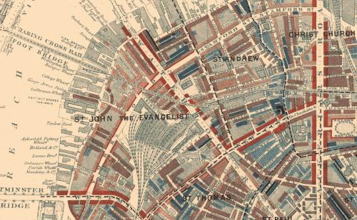
According to the Charles Booth Poverty Map of 1898-99, Whitechapel as a whole appears to be a fairly economically-sound district—with the majority of areas being “fairly comfortable.” Among these areas you will find multiple areas of light blue (“poor”), dark blue (“very poor”), and black (“lowest class [vicious, semi-criminal]”). These areas were the locations of slums.
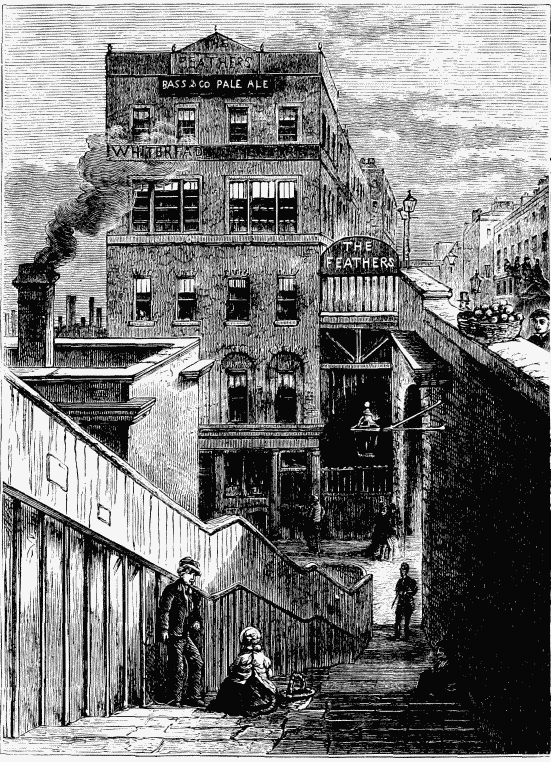
What did these slums look like? As stated previously, Whitechapel was devastatingly poor. As Whitechapel became overcrowded, multiple impoverished families were forced to live together (often up to nine people), crammed into small single rooms. Poverty also created an increase in common lodging houses. In Whitechapel, over 200 common lodging houses were created to house the 8,000+ “homeless and destitute” people per night.  Apart from overcrowding, conditions in these shared houses were atrocious; one of the most predominant issues was the lack of proper ventilation and sanitation. Due to these dreadful environments, diseases like cholera spread (Diniejko).

Crime

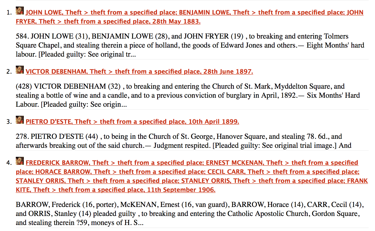
Of all the recorded crimes in Whitechapel from 1837-1901, 2234 records were found with theft being the majority: 1376 cases of basic theft (extortion, embezzlement, pocketpicking, grand larceny, petty larceny, animal theft, etc) and 263 cases of violent theft (robbery, highway robbery, etc.) (Old Bailey).

Though Whitechapel is known for the infamous Jack the Ripper murders, only 95 cases of “killing” were recorded: 41 cases of murder, 51 cases of manslaughter and 3 cases of “infanticide,” “treason,” and “other” (Old Bailey). Though 95 is still relatively high, it in no way makes up the majority of crime in Whitechapel. With that being said, it can be suggested that the murders of Jack the Ripper created more hysteria surrounding the “murderous” conditions in Whitechapel than what existed in reality—though reality was still rather bleak.

Women and Prostitution

Prostitution, however, was a major problem. For many impoverished women living in the East End, prostitution was a primary source of income, “paying anywhere from a loaf of stale bread to three pence.” The estimated total of female prostitutes in Whitechapel in 1888 was 1,200. Prostitution was, of course, not a glamorous trade. By the time women reached the age of twenty, they often would look twice their age due to heavy drinking, as well as their rough lifestyle. Women would often seek comfort in alcohol to escape the reality of their life, often leading to brutality and violence as a result of drunken brawls—a commonplace in Whitechapel (Scanlon).

Slum Clearing

In 1875, the Artisans’ and Laborers’ Dwellings Improvement Act was passed by Parliament. It was an act designed by Richard Cross to buy up the slums, demolish them and then rebuild. Its purpose was “to purge the lawless population of the common lodging houses from the neighborhood” (Jenks)—a way of “demolishing” crime and rebuilding lawful residences and neighborhoods. The first two “test” areas for demolition were the slum areas of Holborn and Whitechapel because they were considered to be some of the most dangerous and immoral (Yelling). The houses targeted in Whitechapel were those on Flower and Dean Street. However, the plan to “remove the nests of disease and crime” backfired. The evicted occupants relocated to Dorset Street and White’s Row, and the cycle continued all over again (Gray).

Whitechapel & Dorian Gray

Whitechapel is mentioned twice within the first five chapters of The Picture of Dorian Gray: in chapter two and chapter three. In chapter two, Dorian realizes that he forgot about his promise to go to the club in Whitechapel with Lord Henry’s aunt: “”I am in Lady Agatha’s black books at present,” answered Dorian with a funny look of penitence. “I promised to go to a club in Whitechapel with her last Tuesday, and I really forgot all about it. We were to have played a duet together – three duets, I believe. I don’t know what she will say to me. I am far too frightened to call.”” In this chapter, Dorian, not yet touched by Lord Henry’s influence, acts with his innocent qualities and feels guilt; his incredibly poor qualities have not yet been unveiled. However, his guilt does not seem to stem from forgetting the people of Whitechapel, but from the fear that he has disappointed someone of higher privilege—Lord Henry’s aunt—and that he will reap the consequences of his negligence.

Furthermore, when he reveals that he “forgot all about” going to Whitechapel, the “hub” of the East End that represents those in poverty, it foreshadows the events to come—especially his treatment of Sibyl Vane and her fate to follow. His disregard for those he deems “beneath” him turns out to be the leading cause of his demise. Just like the government’s disregard for those living in Whitechapel’s slums during the clearings, Dorian’s lack of concern for others in the interest of his own personal gain backfires. He loses more than he gains. (May I also mention the irony of the fact that she works at a theatre in Holborn, the other disregarded location of slum clearings that displaced the lives of already trodden people.)

In chapter three, Lord Henry and Dorian are at Lady Agatha’s for lunch. When Lady Agatha calls Lord Henry out on trying to persuade Dorian to give up the East End, she remarks: “But they are so unhappy in Whitechapel.” In which Henry replies, “I can sympathise with everything except suffering […] I cannot sympathise with that. It is too ugly, too horrible, too distressing. There is something terribly morbid in the modern sympathy with pain. One should sympathise with the colour, the beauty, the joy of life. The less said about life’s sores, the better”  Because Henry is obsessed with art and aesthetic beauty, he chooses to ignore the problems the East End face simply because they are not aesthetically pleasing and therefore, not worthy of his time. His disregard for the problems East-Enders face is later exhibited when Sybil commits suicide and his reaction is not one of horror or pity, but of carelessness as he tries to explain her death in terms of art and beauty.

When Sir Thomas continues by saying, “Still, the East End is a very important problem,” Henry replies, “Quite so […] It is the problem of slavery, and we try to solve it by amusing the slaves.” Lord Henry’s point here is valid. Instead of donating money, clothes, or shelter—the simple life necessities the East-Enders are in dire need of—the wealthy travel to Whitechapel to “amuse” the poor (but mostly, themselves). Their actions do not help the poor, but instead, only gives gratification to the wealthy who want to feel as if they’ve done something “charitable” and “good”—as if the poor need their presence to remind themselves of, and to juxtapose, the impoverished state they find themselves in.

When we return to Whitechapel later in the novel, in chapter eleven, Dorian has ventured into Whitechapel but not for the purposes of charity. Instead, as Dorian becomes more and more corrupt, he begins venturing into the East End for the purpose of committing crimes and doing drugs. Interestingly, when he ventures into the East End, he does not disclose his location to friends and acquaintances. In fact, he goes to the East End in disguise, dressed in the clothes of a commoner. His double life of existing in juxtaposed worlds, the West End and East End, is a direct parallel to his physical and mental double life—the ugliness of his soul and the beauty he wears from the painting. I believe an interesting commentary is being made here about class and location. Dorian, who lives in the wealthy and aesthetically pleasing West End, has the outer aesthetic beauty associated with the West End, but the hideous personality and morals associated with the ugly, run-down East End. Does outer beauty mean you live free of corruption? How much can aesthetic beauty really say about a person, and how much can it really say about the wealthy West End? You can dress up a monster in sleek trousers and a velvet coat, but it’s still a monster. Wilde, I believe, is blurring the lines between what separates the East End from the West. They are two sides of the same corrupted coin.

WORKS CITED

“Booth Poverty Map & Modern Map (Charles Booth Online Archive).” Charles Booth Online Archive. London School of Economics & Political Science, n.d. Web. 23 Nov. 2015.
Diniejko, Andrzej. “Slums and Slumming in Late-Victorian London.” The Victorian Web. The Victorian Web, 3 Oct. 2013. Web. 23 Nov. 2015.
Gray, Drew D. London’s Shadows: The Dark Side of the Victorian City. New York: Bloomsbury, 2010. 122-23. Google Books. Google Books, 1 July 2010. Web. 23 Nov. 2015.
Jenks, Chris. Urban Culture: Critical Concepts in Literary and Cultural Studies. Vol. 4. London: Taylor & Francis, 2004. 197-98. Google Books. Google Books. Web. 23 Nov. 2015.
“The Proceedings of the Old Bailey.” Old Bailey Online. The University of Sheffield, n.d. Web. 23 Nov. 2015.
Scanlon, Gina. “Whitechapel.” BBC America. BBC, 13 Dec. 2012. Web. 23 Nov. 2015.
“Whitechapel’s Sordid History.” Peach Properties. Peach Properties (UK) Ltd., 13 May 2015. Web. 23 Nov. 2015.
Yelling, J. A. Slums and Slum Clearance in Victorian London. New York: Routledge, 2012. 24. Google Books. Google Books, 21 Dec. 2006. Web. 23 Nov. 2015.

Grosvenor Square in A Picture of Dorian Gray

Daniela Velez

Prof. Swafford

ENG 493-02

Final Project, Location: Grosvenor Square in A Picture of Dorian Gray

Screen Shot 2015-11-16 at 10.01.04 AMGrosvenor Square is the home Dorian Gray while he is going about being a bad boy all around the city of London. He also has a home out in the country, Selby Royal. Grosvenor Square is a very upper class area that is completely upper class/wealthy. The outlying area is also upper middle class/well-to-do.Any trace of a lower class area is barely visible and far away.

Screen Shot 2015-11-16 at 10.05.30 AMAccording to a source I found on the British History’s website, Grosvenor Square was built between 1725 and 1731. It was one of the largest upper class squares in the West end and went through many architectural changes over the next two centuries (which would bring us into the time period of Dorian Gray). It is important to note that, “The high social status of the square was nevertheless one of the constants of the estate” (Sheppard). Therefore, it would make sense why Wilde chose this setting to be the center of Dorian’s life in the city.

Screen Shot 2015-11-16 at 10.25.15 AM

The debauchery and hedonistic lifestyle Gray partakes in stands in stark contrast to what one would expect of a resident of Grosvenor Square but it also adds to his dandy/aesthetic image he maintains despite his tarnished reputation. As stated in the excerpt above, the aesthetic movement was almost embodied by Grosvenor Square. Many of the homes were testaments to excess for the sake of excess.


Screen Shot 2015-11-16 at 10.21.02 AMA search of the Old Bailey shows a history of robberies and some crimes around and very few in Grosvenor Square but the map that has these images only go up to 1834. A more narrowed search of the years 1875 to 1913 (the time period we are interested in for our purposes relating to the text since they come before and after the events taking place fictionally) resulted in hits that distinguish Grosvenor Square as defendant’s homes, not the actual place of crimes. There are nine robberies and one case of fraud that actually took place in Grosvenor Square during 1875-1913.

Screen Shot 2015-11-17 at 7.14.38 PMThis makes the murder Gray commits in Grosvenor Square in Chapter Thirteen and the covering up of the crime in Chapter Fourteen, all the more shocking and controversial. It would make Victorian readers question the picture perfect upper class dandy and wonder what evils may lurk in the minds of the upper classes in general. A great moment takes place in Chapter Twelve with the victim and Dorian Gray. Mr. Gray says, “In this fog, my dear Basil? Why, I can’t even recognize Grosvenor Square.” This moment emphasizes the importance of locations and reminds readers to pay attention to what a location implies and how those implications can be undermined.


Works Cited

“Booth Poverty Map & Modern Map (Charles Booth Online Archive).” Booth Poverty Map & Modern Map (Charles Booth Online Archive). N.p., n.d. Web. 17 Nov. 2015.

‘Grosvenor Square: Introduction’, in Survey of London: Volume 40, the Grosvenor Estate in Mayfair, Part 2 (The Buildings), ed. F H W Sheppard (London, 1980), pp. 112-117 http://www.british-history.ac.uk/survey-london/vol40/pt2/pp112-117 [accessed 13 November 2015].

‘Plate 28: Grosvenor Square’, in Survey of London: Volume 40, the Grosvenor Estate in Mayfair, Part 2 (The Buildings), ed. F H W Sheppard (London, 1980), http://www.british-history.ac.uk/survey-london/vol40/pt2/plate-28 [accessed 16 November 2015].

“The Proceedings of the Old Bailey.” Results. N.p., n.d. Web. 17 Nov. 2015.

“Victorian Google Maps Engine.” Google Maps Engine: Map View. N.p., n.d. Web. 17 Nov. 2015.

Waterloo Place in “The Romance of a Shop.”

In Amy Levy’s novel The Romance of a Shop, Waterloo Place is mentioned when talking about The Waterloo Gazette, a newspaper created in the area. Although the women in the story do not visit Waterloo Place, Gertrude turns down an interview with the magazine about her family’s photography shop and her career in general. The text also states, however, that later on “some unauthorised person wrote a little account of the Lorimers’ studio in one of the society papers…” (Levy 135)

Screenshot (2)

As it is clear to see from the map above, courtesy of the London OS Town Plan, Waterloo Place is surrounded by a plethora of clubs, most likely meeting places for upper class citizens, and is also populated by war monuments and artistic statues, including a memorial to commemorate the Crimean War. One of the clubs visible on the map, the Athenaeum Club, was a clubhouse for gentlemen of the upper middle class, who enjoyed the arts, science, and were known for their artistic accomplishments. It was only in 2002 that the club, which still operates to this day, began to admit female members.

mrsid2jpeg

According to the Charles Booth Poverty Map as well, it is obvious that Waterloo Square is in a very wealthy area of London, as if the various sculptures and clubs in the area are not proof enough. On Booth’s charts, both red and orange represent middle class and upper middle class establishments being present, and the overwhelming amount of both colors suggest that Waterloo Place was in the center of a very affluent area. Its close proximity to Piccadilly Circus and the Royal Academy of the Arts also backs up this claim. However, it is interesting to note that on the left side of St. James Square, there is a row of blue dwellings, which indicates that was a smattering of poor families living in the area as well.

Works Cited

Levy, Amy. The Romance of a Shop. Ed. Susan David Bernstein. Canada: Broadview Editions, 2006. p. 135. Print.

Charles Booth Online Archive. Booth Poverty Map and Modern Map. Web. 30 October 2015.  http://booth.lse.ac.uk/cgi-bin/do.pl?sub=view_booth_and_barth&args=529583,180350,1,large,0

London – OS Town Plan 1893-6. Web. 30 October 2015. https://mapsengine.google.com/07550989709782409818-08328807677136535917-4/mapview/?authuser=0


Charing Cross: The Center of the City

Charing Cross

While Charing Cross is not exactly the central point of The Sherlock Holmes story The Man with a Twisted Lip, it is (as some would say) the central point in London and specifically refers to a junction of interconnecting streets. Here, the Strand, Whitehall, The Mall, Cockspur Street, and a few other smaller roads all flow into a roundabout that is located due south of Trafalgar Square. If you were to look at a zoomed out map (like the one seen below), this roundabout seems to be the geographical center of London and though the center could refer to many locations around the same area, it stands to be said that Charing Cross is has been used as a primary indicator of how far one is from the city since the early 1600s. For example, if you were to live in Brighton, one would measure the distance between the two cities by each’s midpoint: London’s being Charing Cross. In fact, because it was so central, coaches could be taken from here to many major cities in England such as Brighton in the south, Dover in the east, Cambridge in the north, and Bath in the west.

Charing Cross modern

As indicated by the Booth Poverty Archive, Charing Cross and the surrounding area is primarily middle class with few wealthy citizens and fewer in the low class. Because of this I assumed that the primary type of criminal activity would be petty larceny—those without money coming to take from those with—but I forgot about the main purpose for Charing Cross: the roadway. I have seen murder and theft time and time again but this was the first time I ever saw any accounts of vehicular manslaughter. Interestingly enough, some were deemed guilty and some were not even though I could not figure out why.

In the Sherlock Holmes story we read, the duo was out in the country (in an area called Lee) and Watson makes a note that they have already been through three other counties. Later on, Sherlock says: “I think, Watson, that you are now standing in the presence of one of the most absolute fools in Europe. I deserve to be kicked from here to Charing Cross.” This is the only mention of Charing Cross in the story, however it explains the importance of location. According to himself, Sherlock’s stupidity should send him walking straight back to London—referred to by its geographical center because they are out in the country.

Baker Street in “Sherlock Holmes: A Scandal in Bohemia”

For this assignment, I decided to focus on what could possibly be the most important setting in a Sherlock Holmes tale, the West End location of Sherlock Holmes’ home, Baker Street.

Frankly, I’ve never been much of a fan of Arthur Conan Doyle or his works, and all I know about Sherlock Holmes and John Watson is that they are detectives, and their headquarters were located at 221B Baker Street in London. It is for this reason I decided to dig a little deeper into its history, and find out exactly what kind of area it was to live in.

First off, it is seen almost immediately in “A Scandal in Bohemia,” as the tale opens with John Watson paying Holmes a visit at his residence on Baker Street, before they are interrupted by a visitor, who turns out to be the King of Bohemia in disguise, looking for the detective’s assistance in foiling a plot by his vengeful mistress, Irene Adler. Judging by the fact that a king could walk down Baker Street (albeit wearing a mask) at night without being accosted by burglars or the like, this gave me the assumption that Baker Street was not a particularly risky place to live.

Screenshot (49)

As you can see from the above map from the 1890s, Baker Street was surrounded by many hotels on nearby streets, giving the impression that it was located in an upper class area that was prime for travelers to stay in. There was also a tube station on the street in later years, and was located close to a fire station, which would have made the residents of Baker Street a priority for the fire brigade if there were ever an emergency, judging by their close proximity. There was also the large Baker Street Bazaar, a shopping area where people came to buy food, clothing, and see exhibits, such as an early version of the famed Madame Tussaud’s wax museum. This backs my belief that Baker Street was in a well-to-do area of London, populated by the middle class and the wealthy and with little crime.

bakerstreetbazaar

Above: The Baker Street Bazaar, as seen in 1845 for a cattle show.

Truth be told, while searching the Old Bailey Proceedings for news of crimes committed on Baker Street, I could find only victims and other witnesses that gave their addresses as Baker Street, and no crimes that were actually committed there. I thought I may have found an animal theft occurring on Baker Street in an account describing the arrest of one George Welldon, but it turns out that the defendant lived on Lloyd Baker Street in Clerkenwell.

Overall, Baker Street seemed to be located in a safe, upper class community, and today is home to the Sherlock Holmes Museum, located, not surprisingly, at 221B. The legacy of Sherlock Holmes and his living place on Baker Street continues to shape the street’s fame and economic value even today.

“Adventure I. – A Scandal in Bohemia.” The Strand Magazine: Adventures of Sherlock Holmes. Vol. 1. Stanford: Stanford U, 2006. N. pag. The Strand Magazine. Stanford University, 27 Jan. 2006. Web. 17 Oct. 2015. <http://sherlockholmes.stanford.edu/pdf/holmes_01.pdf>.

“London – OS Town Plan 1893-6: Baker Street, London.” Google Maps Engine: Map View. N.p., n.d. Web. 17 Oct. 2015. <https://mapsengine.google.com/07550989709782409818-08328807677136535917-4/mapview/?authuser=0>.

Old Bailey Proceedings Online (www.oldbaileyonline.org, version 7.2, 17 October 2015), October 1768, trial of George Welldon (t17681019-34).

The Sherlock Holmes Museum. Digital image. The Fussiest Eater. Web. 17 Oct. 2015. <http://www.thefussiesteater.com/2012/06/the-sherlock-holmes-museum-221b-baker-st-london/>.

Jackson, Lee. Baker Street Bazaar. Digital image. Victorian London. Nassau Steam Press, n.d. Web. 17 Oct. 2015. <http://www.victorianlondon.org/shops/bazaars.htm>.

Waterloo Bridge Road


Waterloo Bridge Rd. was the combined Waterloo Bridge and Waterloo Street. The road mentioned in “Man With A Twisted Lip”  which turns into Wellington Street is Waterloo Bridge Road. “The formation of Waterloo Bridge—which was 1completed and opened on the 18th of June, 1817—as may be expected, soon made a great alteration in the appearance of Southern London, especially in those parts lying between Blackfriars and Westminster Bridge Roads” (Lambeth). Its name commemorates the victory of the British, the Dutch and the Prussians at the Battle of Waterloo in 1815. The approaching road and other various areas of London also share the name Waterloo in respect and honor.
The area was mostly middle class, at least on the main street. Waterloo Bridge Road was part of the parishes of St Andrew, St John, St Thomas [Lambeth]and Christ Churcmrsid2jpeg.plh (Charles Booth). Most of the crime committed in the area was theft and a handful of highway robberies that may have ended on the bridge itself. Overall the information on Waterloo Bridge Road is scarce. Most of it is about the surrounding area, the bridge and its southern approach have little influence to the surrounding areas.
Even in “Man With A Twisted Lip” the Road is but a way across the river.  “Passing down the Waterloo Bridge Road we crossed over the river, and dashing up Wellington Street…”(Doyle). The river divides London, it also helps divide class. This can be seen in the story as crossing the water is linked to crossing classes and lifestyles. This crossing of the bridge represents the crossing of themes in the story.
Waterloo Bridge Road is the southern approach to Waterloo Bridge. The Bridge approach was built on a piece of ground which for many years was part of Cuper’s (or Cupid’s) Garden. The road
“One of the earliest buildings in Waterloo Road was the Royal Universal Infirmary for Children. This institution was the successor of the Universal Dispensary for Sick and Indigent Children founded in 1816… The infirmary was built on land which was part of the triangular slip of ground bought by the Waterloo Bridge Company from Jesus College, Oxford, and assigned to the Duchy of Cornwall in exchange for ground given up to form the bridge approaches.”(Waterloo Road).

Works Cited
“Charles Booth Online Archive.” Search Survey Notebook Pages (Charles Booth Online Archive). Web. 16 Oct. 2015.

Doyle, Arthur Conan. The Man with the Twisted Lip. N.p.: n.p., n.d. Print.

“Lambeth: Waterloo Road.” Lambeth: Waterloo Road. Web. 16 Oct. 2015.

‘Waterloo Road.’ Survey of London: Volume 23, Lambeth: South Bank and Vauxhall. Ed. Howard Roberts and Walter H Godfrey. London: London County Council, 1951. 25-31. British History Online. Web. 14 October 2015. http://www.british-history.ac.uk/survey-london/vol23/pp25-31.

Chancery Lane, London

Screen Shot 2015-09-09 at 8.47.00 PMScreen Shot 2015-09-09 at 11.12.00 PM
Chancery Lane is mentioned once in George Egerton’s “A Lost Masterpiece” and is the location of the story’s climax: “It was near Chancery Lane that a foreign element cropped up and disturbed the rich flow of my fancy.” During my research, I found that Chancery Lane was a middle class area where the “well-to-do” lived. Along Chancery Lane one could find numerous banks and law houses. Two important law buildings that resided in the area were Lincoln’s Inn and Roll’s House. Lincoln’s Inn was home to England’s second most powerful court, the Court of Chancery. Lincoln’s Inn was a court of equity, meaning that it dealt with cases concerning money: wills, monetary fraud, tax raises etc. The atmosphere of Lincoln’s Inn is described as “the best locality for observing the physiology of legal life” (Jackson). The Roll’s House is where the rolls and records of the court are kept.
018D2117-AA18-4386-BDA2-5700D9B279D2
Outside of Lincoln’s Inn is Lincoln’s Inn Fields. Lincoln’s Inn Fields was considered the handsomest and largest square in London, but was also littered with crime: “beggars by day and of robbers at night” (Thornbury). In Lincoln’s Inn Fields it was not uncommon to find vagrants and cripples who begged for money and went to extremes to come off as pitiful beings.
5E583063-CD06-415F-A98C-AFAB1363846D
Chancery Lane as a place of sneaky crime and prestigious court ties in with “A Lost Masterpiece.” In the story, the narrator is traveling through London after having returned from the countryside. After arriving in London, the narrator begins growing ideas in his head that he believes to be the start of a masterpiece. However, once he arrives to Chancery Lane, he sees a woman who “disturbed the rich flow of [his] fancy.” The woman was dressed professionally and was walking with haste. The sight and image of the woman disrupts the man’s thought process and he loses the idea he believed to be brilliant. He gets angry at the woman as if her very presence was a crime within itself: “What business had she, I ask, to come and thrust her white-handled umbrella into the delicate net work of my nerves and untune their harmony?” Although the woman’s presence is not actually a crime, it becomes ironic because of the location. 
Works Cited
“Booth Poverty Map & Modern Map (Charles Booth Online Archive).” Charles Booth Online Archive. London School of Economics & Political Science, n.d. Web. 10 Sept. 2015.
Egerton, George [Mary Chavelita Dunne Bright]. “A Lost Masterpiece.” The Yellow Book 1 (Apr. 1894): 189-96. The Yellow Nineties Online. Ed. Dennis Denisoff and Lorraine Janzen Kooistra. Ryerson Universty, 2010. 9 September 2015.
Jackson, Lee. “Victorian London – Legal System – Courts – Chancery.”Victorian London – Legal System – Courts – Chancery. The Victorian Dictionary, n.d. Web. 09 Sept. 2015.
Thornbury, Walter. ‘Lincoln’s Inn Fields.’ Old and New London: Volume 3. London: Cassell, Petter & Galpin, 1878. 44-50. British History Online. Web. 10 September 2015.

Chelsea: Connecting East and West London

Screen Shot 2015-09-10 at 12.43.45 AMLocated in the northwestern region of London, Chelsea was a predominantly well-off and bustling neighborhood that revolved around Chelsea Rd. and the Chelsea Rd. Bridge. In “A Lost Masterpiece,” the main character (who remains nameless) makes his way to the Chelsea wharf and there loads a steamer to travel east up the Thames River. Interestingly enough, Chelsea’s wharves were the first ferry transportation portals along the Thames River, which made Chelsea a fast-developing part of London. In 1816, the steamboat was introduced to the Thames River and by the 1830’s steamboat traffic was  booming, especially between Chelsea Bridge and London Bridge. Not only did the town of Chelsea serve as a gateway due to the many wharves that popped up along the Thames, but the Chelsea Bridge also became one of the most used roads/highways by this time as well, as it connected the Royal Hospital to the rest of London .

The Chelsea Bridge was erected sometime during the 15th century, under the name Battersea Bridge, but with the introduction of auto-transportation, Chelsea’s reputation of being a travel hub continually grew. With so much access to and from Chelsea, it seems as though during the Victorian Era, and probably the eras to follow as well, Chelsea was a major part of London that really allowed Londoners to use the Thames River for travel. The article, “The parish of Chelsea: Communication,” explains, “in 1844 eight steamboats travelled between London Bridge and Chelsea, four times an hour, and traffic was increasing. Chelsea vestry saw steamboats – quick, cheap, and comfortable – as potentially the common transport of residents of the densely-populated shore.” Egerton’s main character makes this journey in “A Lost Masterpiece,” which is significant because Chelsea Bridge and wharf is what connects the Western wealthy end of London to the slummy, factory ridden east end. The Booth Poverty map shows that during the Victorian era, the areas in and around Chelsea were populated well-to-do- middle-classers, while the area around London Bridge is shaded to indicate the poverty and crime. Chelsea’s bringing together of the contrasting regions of London is also apparent in the way the main character describes his observations once getting off the steamer by London Bridge. He does not see the filth and poverty surrounding him, rather finds the east-end of London delightful and curious:

“The youth played mechanically, without a trace of emotion; whilst the harpist, whose nose is a study in purples and whose bloodshot eyes have the glassy brightness of drink, felt every touch of beauty in the poor little tune, and drew it tenderly forth. They added the musical note to my joyous mood ; the poetry of the city dovetailed harmoniously with country scenes too recent to be treated as memories—and I stepped off the boat with the melody vibrating through the city sounds.”

Although his main character sees the industrial area through an optimistic lens, Egerton’s mention that the music was played mechanically and without emotion is indicative of the actual situation and quality of life that was present in the eastern portion of London. Although the music the main character hears adds more joy to his already joyous mood, the way in which the music is produced is melancholy and representative of the proletariat’s factory labor, which only benefits the bourgeoisie, as the sad music only benefited the seemingly wealthier observing character. Through his mention of Chelsea, especially as the port town the main character uses to access the slums, Egerton is calling attention and awareness to the two extremely opposing “Londons” within the City of London.


Works Cited

Booth, Charles. “Booth Poverty Map & Modern Map (Charles Booth Online Archive).” Booth Poverty Map & Modern Map (Charles Booth Online Archive). London School of Economics & Political Science, n.d. Web. 09 Sept. 2015.

Egerton, George [Mary Chavelita Dunne Bright]. “A Lost Masterpiece.” The Yellow Book 1 (Apr. 1894): 189-96.The Yellow Nineties Online. Ed. Dennis Denisoff and Lorraine Janzen Kooistra. Ryerson University, 2010. Web. 09 Sept. 2015.

‘Settlement and building: From 1680 to 1865, Chelsea Village or Great Chelsea’, in A History of the County of Middlesex: Volume 12, Chelsea, ed. Patricia E C Croot (London, 2004), pp. 31-40. Web. 09 Sept. 2015.

‘The parish of Chelsea: Communications’, in A History of the County of Middlesex: Volume 12, Chelsea, ed. Patricia E C Croot (London, 2004), pp. 2-13. Web. 09 Sept. 2015.