Euston Road- Final Project

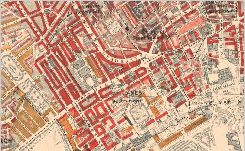
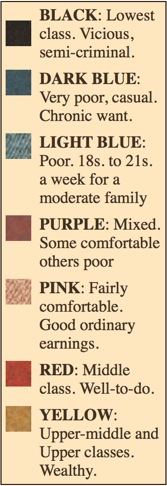
The Vane family (Sibyl, James, and their mother) lives on the residential street, Euston Road. Their apartment is in close proximity to the Euston Station. According to the Charles Booth Online Archive, the area surrounding Euston Square is mixed. The majority of residents are Middle Class, well-to-do, and the rest are split between comfortable and poor and Upper class and wealthy.

Screen Shot 2015-12-10 at 4.01.46 PM      Screen Shot 2015-12-10 at 4.02.07 PM


The poverty maps are very important in understanding the life of Sibyl Vane. Mrs. Vane brought up her children with the intentions of bettering their lives. She does this through upgrading them in appearances. When James is leaving for Australia and remarks how he will be leaving London hopefully for good, Mrs. Vane objects his disdain. When he returns she hopes he will make a name for himself in London and become a gentleman. Mrs. Vane’s approval of Dorian stems from exactly that;

“Of course, if this gentleman is wealthy, there is no reason why she should not contract an alliance with him. I trust he is one of the aristocracy. He has all the appearance of it, I must say. It might be a most brilliant marriage for Sibyl. They would make a charming couple. His good looks are really quite remarkable; everybody notices them” (Chapter 5).

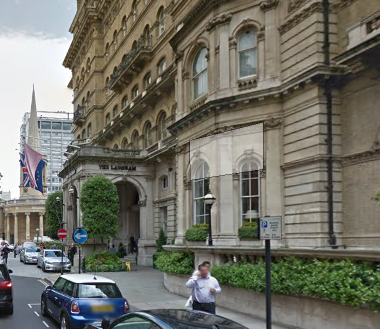
Her lack of familiarity with Dorian is erased by the fact he is established in society. This is the reasoning behind the location of their apartment. Mrs. Vane is indebted to Mr. Isaac yet they still live in an area with easy access to affluence. Euston Square is within walking distance and King’s Cross Station is nearby as well. residential Euston Road. Sibyl and James have access to all of London from their location. Therefore, she increases the opportunities for her family.

Screen Shot 2015-12-11 at 3.40.57 PM

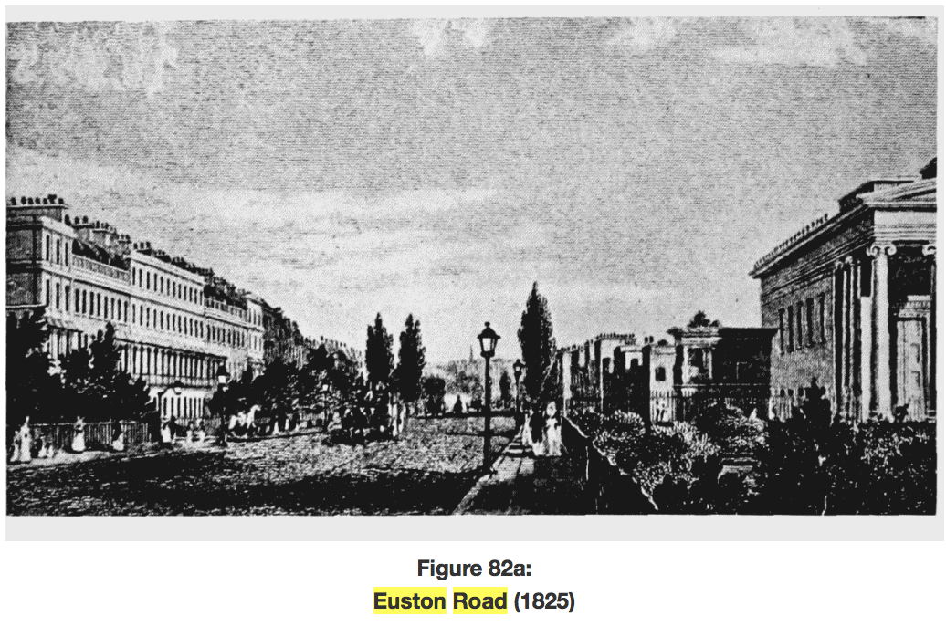
Euston Road, originally named New Road was constructed by the Metropolitan Railway Company. Tracks covered Euston Road entirely which, in turn, tore up the road. After completely the railway whilst simultaneously destroying the roadway, the company re-made the road, turning it into one of the finest in London. It was sanctioned by Act of Parliament in 1756 (Euston Road and Hempstead Road). The buildings on Euston Road had rather large yards with shrubbery in front to maintain a residential atmosphere. Euston Road was designed to accommodate the growing population of London. Although there were wealthy families living in the area, there was a represented lower class population, such as the Vane family.
The crime is abundant in the area. There are cases of stealing from one’s master, manslaughter, forgery, theft, deception, killing and disturbing of peace. From the information on Old Bailey Online, it is evident that there was a fair amount of criminal activity in the neighborhood. This is suggestive of the types of citizens who live in the area. Although there are parks nearby and Euston Square, there are still people there who are struggling to make ends meet. Euston Road is described as dreary in Picture of Dorian Gray, but the park is described as a place for swell people.
Thus, drab and fabulous are juxtaposed next to each other in Sibyl’s neighborhood. James walking with his sister on Euston Road is a “common gardener walking with a rose” (Chapter 5). Sibyl’s beauty contrasts her surroundings suggesting that she does not belong there and a place that better suits her is nearby (Euston Square/ Dorian Gray).

Works Cited
“Booth Poverty Map & Modern Map (Charles Booth Online Archive).” Booth Poverty Map & Modern Map (Charles Booth Online Archive). N.p., n.d. Web. 11 Dec. 2015.

“The Proceedings of the Old Bailey.” Results. The Proceedings of Old Bailey. Web. 11 Dec. 2015.

Walford, Edward. ‘Euston Road and Hampstead Road.’ Old and New London: Volume 5. London: Cassell, Petter & Galpin, 1878. 301-309. British History Online. Web. 9 December 2015.

Piccadilly

Screen Shot 2015-12-02 at 7.40.13 PM

With development starting as early as the sixteen hundreds, Piccadilly runs across London and serves as the main highway that connects the west end to the east end (Piccadilly, Southside). Piccadilly runs just north of Green Park and south of the Royal Academy and meets Regent Street at the famous Piccadilly Circus. Not only did Piccadilly serve as the gateway from the West to the metropolitan area of England, but it was also the site of many newly erected mansions throughout the seventeenth century. Right from the beginning of Piccadilly’s history, the street has been an area of wealth, as we can see on the Booth Online Poverty Map.

Screen Shot 2015-12-02 at 7.44.05 PM

Due to the area’s apparent wealth, throughout history, this area has been the setting for political grounds. In the article, “Mansions in Piccadilly,” we learn that, “For a century and a half this house has been one of the special rendezvous of the Whig party. “Three palaces in the year 1784,” writes Sir N. W. Wraxall, “the gates of which were constantly thrown open to every supporter of the ‘Coalition’ (against Pitt), formed rallying-points of union.” One of these was Burlington House, then tenanted by the Duke of Portland; the second was Carlton House, the residence of George, Prince of Wales; the third was Devonshire House, which, ‘placed on a commanding eminence opposite to the Green Park, seemed to look down upon the Queen’s House, constructed by Sheffield, Duke of Buckingham, in a situation much less favoured by nature.'” Due to Piccadilly’s plethora of wealth, many shop owners, especially booksellers, started opening up stores in what is now known as one of the most famous shopping areas of London. Many book shops and publishing houses were opened up, and by, “1850 or 1851 the firm of Chapman and Hall came from the Strand to No. 193 Piccadilly, where it remained until its removal to Henrietta Street, Covent Garden, in 1881. Chapman and Hall’s authors included the Brownings, Trollope, Meredith and Dickens” (Piccadilly, South Side). This area became more and more popular, especially for authors and other cultured people. Soon enough, the Royal Academy was developed right off Piccadilly, as well as restaurants, inns, and many more shops.

As Dorian describes how he met Sibyl Vane to Lord Henry, he begins by telling Lord Henry, “As I lounged in the Park, or strolled down Piccadilly, I used to look at every one who passed me, and wondered, with mad curiosity, what sort of lives they led” (52). We learn that Dorian, instead of roaming around the wealthy, cultured neighborhood of which he was a part, decides to head eastward in order to find true beauty. It is interesting that Dorian, although immersed in the arts, wealth, and beauty of Piccadilly, felt he needed to seek true beauty elsewhere; this detail, in my opinion, foreshadows Dorian’s spiral downward. He no longer finds beauty in the intellectual and artistic aspects of his upper-class life, rather finds amusement through grime and sin.

Works Cited

“Piccadilly, South Side.” Survey of London: Volumes 29 and 30, St James Westminster, Part 1. Ed. F H W Sheppard. London: London County Council, 1960. 251-270. British History Online. Web. 1 December 2015.

Walford, Edward. ‘Mansions in Piccadilly.’ Old and New London: Volume 4. London: Cassell, Petter & Galpin, 1878. 273-290. British History Online. Web. 1 December 2015.

Wilde, Oscar. The Picture of Dorian Gray. New York: Barnes & Noble Books, 2003. Print.

Burlington Street and Arcade

Screen Shot 2015-11-27 at 8.00.03 PM

In The Picture of Dorian Gray, we learn about Dorian’s mysterious family history through Lord Henry’s uncle, Lord George Fremor. As Lord Henry leaves his uncle’s house, Wilde writes, “Lord Henry passed up the low arcade into Burlington Street, and turned his steps in the direction of Berkeley Square. Upon leaving his uncle, Lord Henry tells him how he will be having lunch with Aunt Agatha’s, who seems to live in the same well-off area as Berkeley Square is in. Burlington Street, which is actually called Old Burlington Street, runs parallel to Burlington Garden, which parallel to, yet accessible through the Burlington Arcade.

Screen Shot 2015-11-27 at 8.05.41 PM

The Burlington Arcade, which was started in May 1815, serves as the entranceway for The Royal Academy of Arts, the Burlington House, and the University of London. This area is extremely well off, as we can see on the Booth Poverty Map.

Screen Shot 2015-11-27 at 8.36.31 PM

The Burlington Arcade, which is virtually the only passageway into Burlington Gardens, was one of the first confined establishment of high-end shops, as explained in the article “Burlington Arcade:”

aba-c-aba-c-aba-c-aba-d: Here ‘a’ represents a ‘double’ shop, with small display window flanked by doors and by larger display windows, and one storey visible above where one plain window is flanked by two bay windows; ‘b’ represents two smaller, separate shops, or ‘single’ shops, with one visible storey above them, where two plain windows are between two bay windows; ‘c’ is a heightened version of ‘a’ and takes the place of the ‘inter-shop’ spaces or ‘saloons’ earlier proposed, the three-storey fronts being set back from the building line; and ‘d’, between street entrance and first arch, represents one ‘single’ shop plus one double shop splayed back from the street entrance. The width of the passage at each arch is constant, some 12 feet.

Burlington Arcade was most known for its architecture and ability to house so many small shops. This is significant to Wilde’s story because it really exhibits how well off Lord Henry and Dorian Gray seem to be. Lord Henry’s route through Burlington Arcade and (Old) Burlington Street may be related to the story he just heard about Dorian’s family. Upon hearing the oddly mysterious story, Lord Henry walks toward an extremely well off area of London, which could represent Dorian Gray’s wealth, despite his obscure family history.

Works Cited

“Booth Poverty Map. Charles Booth Online Archive. London School of Economics and Political Science. Web. 27 November 2015.

‘Burlington Arcade.’ Survey of London: Volumes 31 and 32, St James Westminster, Part 2. Ed. F H W Sheppard. London: London County Council, 1963. 430-434. British History Online. Web. 27 November 2015.

Victorian Google Maps.

Wilde, Oscar. The Picture of Dorian Gray. New York: Barnes & Noble Books, 2003. Print.

Euston Road

Screen Shot 2015-11-15 at 6.51.23 PM

In Oscar Wilde’s The Picture of Dorian Gray, Dorian Gray’s fiancé, Sibyl Vane, lives on Euston Road with her mother and brother James. Euston Road runs parallel to the Thames, between The Regent’s Park and Hyde Park, and is the closest main road to the Euston Station, which connects to the road via Euston Grove (Victorian Google Maps). Camille Cauti, who provides the Introduction and Notes for my edition of Dorian Gray, comments that Euston Road is a, “Street in North London lined with inexpensive lodging” (69). Euston Road, originally called the “New Road,” was sanctioned to be built in 1756 to connect Paddington and Islington within London (Walford, “Euston Road”). Not only was the road constructed to further connect one end of London to the other, but Euston Road was also meant to provide a residential living area for the growing population of London: “The result was that the road was wholly residential, with long gardens in front of the houses and this pleasant effect was increased by laying out open squares which faced one another, such as Park Square and Crescent, Endsleigh Gardens and Euston Square. Mackenzie’s view (Plate 82a) shows the road in 1825 at the height of its fashion” (“Euston Road”). But by the time Oscar Wilde was writing Dorian Gray though, which would be at least fifty years from 1825, the beauteousness of Euston Road seemed to fade into what Wilde refers to as, “the dreary Euston Road.” (Wilde, 69). In the novel, Sibyl suggests to Jim that they visit the Park, unto which Jim responds, “‘I am too shabby,’ he answered, frowning. ‘Only swell people go to the Park” (Wilde 67). The siblings decide to go to the Park that is above their class anyway, and must walk down Euston Road to reach the Park. Sibyl and Jim’s walk down Euston Road is important in understanding Sibyl’s shift from poverty to prestige–or at least the facade of prestige that Dorian Gray is as a park is to nature. Euston Road, both historically and fictionally, seems to represent a type of transition, or rather fading, from one state of being to another.

Camille Cauti, Introduction. The Picture of Dorian Gray. By Oscar Wilde. New York: Fine Creative Media Inc., 2003. Print.

“Euston Road.” Survey of London: Volume 24, the Parish of St Pancras Part 4: King’s Cross Neighbourhood. Ed. Walter H Godfrey and W McB. Marcham. London: London County Council, 1952. 114-117. British History Online. Web. 15 November 2015.

Victorian Google Maps. Google Imagery 2015. 

Walford, Edward. ‘Euston Road and Hampstead Road.’ Old and New London: Volume 5. London: Cassell, Petter & Galpin, 1878. 301-309. British History Online. Web. 15 November 2015.

St. George’s church

Screen Shot 2015-11-04 at 5.00.45 PM

St. George Street is located in at the corner of George Street and Margaret street. According to Charles Booth, this area consisted mostly of middle and upper class citizens. The church first opened its doors on September 4 1850, and it was created to serve a Roman Catholic population of immigrants coming from Ireland. The two architects were Joseph and Charles Hansom and their builder Ralph Witherly from York.

mrsid2jpegIn Romance in a Shop, Conny has a conversation with Gertrude about how she spends much of her time at Saint George and how she has no interest in getting married. She is much more content spending time under a glass ceiling (conservatories). Compared to how much life is changing for her other sisters, while hers seems to not give in to giving up on the new woman idea.

‘Parish Church of St. George.’ An Inventory of the Historical Monuments in City of York, Volume 5, Central. London: Her Majesty’s Stationery Office, 1981. 20. British History Online. Web. 30 October 2015. http://www.british-history.ac.uk/rchme/york/vol5/p20.

Charing Cross: The Center of the City

Charing Cross

While Charing Cross is not exactly the central point of The Sherlock Holmes story The Man with a Twisted Lip, it is (as some would say) the central point in London and specifically refers to a junction of interconnecting streets. Here, the Strand, Whitehall, The Mall, Cockspur Street, and a few other smaller roads all flow into a roundabout that is located due south of Trafalgar Square. If you were to look at a zoomed out map (like the one seen below), this roundabout seems to be the geographical center of London and though the center could refer to many locations around the same area, it stands to be said that Charing Cross is has been used as a primary indicator of how far one is from the city since the early 1600s. For example, if you were to live in Brighton, one would measure the distance between the two cities by each’s midpoint: London’s being Charing Cross. In fact, because it was so central, coaches could be taken from here to many major cities in England such as Brighton in the south, Dover in the east, Cambridge in the north, and Bath in the west.

Charing Cross modern

As indicated by the Booth Poverty Archive, Charing Cross and the surrounding area is primarily middle class with few wealthy citizens and fewer in the low class. Because of this I assumed that the primary type of criminal activity would be petty larceny—those without money coming to take from those with—but I forgot about the main purpose for Charing Cross: the roadway. I have seen murder and theft time and time again but this was the first time I ever saw any accounts of vehicular manslaughter. Interestingly enough, some were deemed guilty and some were not even though I could not figure out why.

In the Sherlock Holmes story we read, the duo was out in the country (in an area called Lee) and Watson makes a note that they have already been through three other counties. Later on, Sherlock says: “I think, Watson, that you are now standing in the presence of one of the most absolute fools in Europe. I deserve to be kicked from here to Charing Cross.” This is the only mention of Charing Cross in the story, however it explains the importance of location. According to himself, Sherlock’s stupidity should send him walking straight back to London—referred to by its geographical center because they are out in the country.

The Langham Hotel

Screen Shot 2015-10-18 at 7.55.29 PM

According to the Langham hotel website, “Delighting guests with gracious hospitality since 1865.” The Langham hotel was originally designed in the year of 1858, but unfortunately the plans to begin building the hotel failed. It wasn’t until the year of 1863 where the foundation for the hotel was created by two architects named Giles and Murray. The hotel “was opened in June, 1865, with a luncheon at which the Prince of Wales was present;” This hotel has been one of the most luxurious hotels in London with its spacious rooms and tall ceilings. The hotel is “It measures upwards of 200 feet in the facade looking up Portland Place, and is upwards of 120 feet in height, the rooms rising to a sixth storey, and overtops by some forty or fifty feet all the mansions in Portland Place and Cavendish Square” making it one of the biggest buildings of that area.

Screen Shot 2015-10-18 at 8.00.29 PM

The hotels architecture was very simple and can be described as italian style. Although the hotel looked very simple, it attracted many people of class and money, which is evident in Sherlock Holme’s A Scandal in Bohemia. This hotel is mentioned during the meet up between Holme’s and The King. The King was using this hotel as a form of hiding out with Miss adler, where he was checked in under the name “Count Von Kramm.” The King, a man of high class and power, was expected nothing less than to stay at the richest and highest hotel, even if he was doing scandalous things. To this day, this hotel continues its reputation by providing those staying with good, high quality  services.


Walford, Edward. ‘Oxford Street and its northern tributaries: Part 2 of 2.’ Old and New London: Volume 4. London: Cassell, Petter & Galpin, 1878. 441-467. British History Online. Web. 13 October 2015. http://www.british-history.ac.uk/old-new-london/vol4/pp441-467.

“Hotel Overview | London Luxury Hotel | The Langham, London.” Hotel Overview | London Luxury Hotel | The Langham, London. N.p., n.d. Web. 18 Oct. 2015.


Threadneedle Street

Screen Shot 2015-10-18 at 5.58.57 PM

Threadneedle Street is a street in which the characters of Doyle’s short story, “The Man with the Twisted Lip,” part of The Adventures of Sherlock Holmes, refer to as the City. The story starts off with Watson on a mission to retrieve a friend from the opium den on Swandam Lane, and while at the opium den, runs into Sherlock Holmes, who is there investigating the potential murder of Mr. Neville St. Clair. The prime suspect for St. Clair’s murder is the poor beggar, Hugh Boone, who lives in the apartment above the opium den. Hugh Boone is described as a decrepit beggar who, “though in order to avoid the police regulations he pretends to a small trade in wax vestas. Some little distance down Threadneedle Street, upon the left-hand side, there is, as you may have remarked, a small angle in the wall. Here it is that this creature takes his daily seat…” (7). This description, given by Watson is important in not only figuring out the mystery of the story, but also what Threadneedle Street was like during the early nineteen hundreds.

Threatneedle Street is the street that runs parallel to Cornhill and perpendicular to Bishopgate Street, forming a triangle north of the Thames River. The triangle these three streets form is the center of business in London, as the Royal Exchange and Bank of London are located between the three streets (Victorian Google Maps). The Royal Exchange, started by Mr. Edward Moxhay in 1830, under the name The Hall of Commerce, as an area for merchants to gather and trade without the threat of larger, monopolizing businesses (Thornbury). Due to it being the home of the Royal Exchange, Threadneedle Street is important to understanding the context of Doyle’s story. Threadneedle Street is where Hugh Boone “works,” because even for a beggar there is more opportunity in the heart of the city, as opposed to where he lives, which is in the opportunity-less slums. Doyle’s inclusion of the contrast between a beggar’s opportunity in the City and by the opium dens suggests how it is inevitable, even if one needs to be a beggar, to be a part of modernized London.

Threadneedle Street is also the home of the Bank of London, the Jewish synagogue-turned-school-turned-Church-turned-bank (Thornbury). The Bank of London is not only significant to this location in real life as well as the plotline of “The Man with the Twisted Lip,” due to its obvious financial role, but also due to the vast history the establishment holds. The Bank’s history reinforces how diverse and important of an exchange place Threadneedle must have been especially during the eighteenth and nineteenth century. Before the building was an active part of the financial-driven part of London, it went through many different stages of being social and institutional centers, thus proving the importance and versatility of this area; no wonder why Boone decided to beg there. Not only is the Bank of London located on Threadneedle, but also the street is lined with dozens of other smaller banks and exchanges (Victorian Google Maps).

In terms of theme, Threadneedle Street is significant in displaying the layered contrasts between the working class of London, the beggars of London, and the “CEOs” of London, which allows readers to understand and imagine 1850-1900’s London with more clarity. The City, which is how the characters of the story refer to the Threadneedle district, is a melting pot of all the different prototypes that make up the capitalist, modern system in which London has developed due to the introduction of industrialization. Due to the competition introduced by industrialization, small merchants such as Mr. Moxhay found it integral to create a space in which more fair competition can exist. In doing so, the financial world created itself around the merchants’ power to congregate and establish grounds and due to the district’s financial boom, others, such as beggars, also establish themselves and function around the systems established. This multi-layered development of what Threadneedle Street represents is the beginning of London’s full-fledged transformation into the modern City.

Works Cited:


Doyle, Sir Anthony Conan. “Adventure 6: The Man with the Twisted Lip.” The Adventures of Sherlock Holmes. London: George Newnes Ltd, 1892. Florida Center for Instructional Technology, College of Education, University of South Florida. 2015. Oct 18 2015.

Thornbury, Walter. “Threadneedle Street.” Old and New London. Vol. 1. London: Cassell, Petter & Galpin, 1878. 531-544. Oct 18 2015.

“London – OS Town Plan 1893-6.” Google Maps Engine. Google-Imagery TerraMetrics, 2015. Oct 18 2015.

Katelynn Vyas Intro Post

Hello, my name is Katelynn Vyas. Please call me Katie. I am an Early Childhood Education major, with a concentration in English and a euphoric senior. I am pleased to be a member of the “Virtually London” class here at SUNY New Paltz. Although I visited Westminster Abbey as a child, watched the changing of the guard at Buckingham Palace and toured the Tower of London, I remember little. However, with my newfound knowledge I intend one day soon to be a groundling at the Globe Theater, tour the birthplaces of British authors and afterward return to Piccadilly Circus in order to savor pasties once again.

From the reading, it is extremely interesting to note that throughout the history of London prosperity and change in the monarchy brought about hardship to its inhabitants (Robinson). Ironically, as an imperialistic nation the empire was known internationally for causing the social, economic, religious and political change in the nations it conquered. It is sad to learn Londoners also lived in extreme poverty, in utter filth and with daily threats of violence while the empire did little to improve the lives of its constituents. None the less, London became a thriving seaport with a growing population and a prosperous financial center (Robinson). It was clearly poised to experience the first industrial revolution in the world. The reading clearly states the Thames River was a geographical land mass that served to delineate the north from the south, the haves from the have-nots (Robinson). In the 1700’s the south became the area in which heavy industry was located and in which the working class poor were situated. Author and social commentator Charles Dickens wrote about poverty, disease, vice and the general lack of empathy of the monarchy toward the working class poor in 19th century England (Robinson). I am looking forward to walking through Adelphi, the location of Dickens’ lodgings and where David Copperfield lived (Perdue .Map 1). Virtually visiting London’s historical stomping grounds and places such as Covent Garden (Perdue. Map: D-6), Charing Cross (Perdue.Map: E-5), and the British Museum (Perdue.Map: B-5) will greatly enhance my understanding of Victorian London.

Perdue, David. “David Perdue’s Charles Dickens Page – Dickens’ London Map.”  David Perdue’s Charles Dickens Page – Dickens’ London Map. Davd Perdue. Web. 26 Aug. 2015.

Robinson, Bruce. “London: ‘A Modern Babylon’” BBC News. BBC, 11 Feb. 2011. Web. 25 Aug. 2015.

Welcome!

Welcome to “Virtually London”! This class uses digital humanities–the practice of using digital tools for scholarly purposes—to study London through the literature of the Victorian era (1830-1900). We will use digital archives to examine Victorian poetry alongside paintings, digitally map the paths of characters throughout London in Victorian novels, and build a digital archive of Victorian LGBTQ writers. The course will show the vibrancy and multifaceted nature of the Victorian period through an interdisciplinary approach that will appeal to those interested in English, History, Sociology, and Women’s, Gender, and Sexuality Studies.

Course Materials:

All readings except for Amy Levy’s The Romance of a Shop can be found online through the course website.

Levy’s novel can be found in the bookstore, can be purchased online in print, PDF, and ePub format or Kindle format.