
In Amy Levy’s novel The Romance of a Shop, Waterloo Place is mentioned when talking about The Waterloo Gazette, a newspaper created in the area. Although the women in the story do not visit Waterloo Place, Gertrude turns down an interview with the magazine about her family’s photography shop and her career in general. The text also states, however, that later on “some unauthorised person wrote a little account of the Lorimers’ studio in one of the society papers…” (Levy 135)
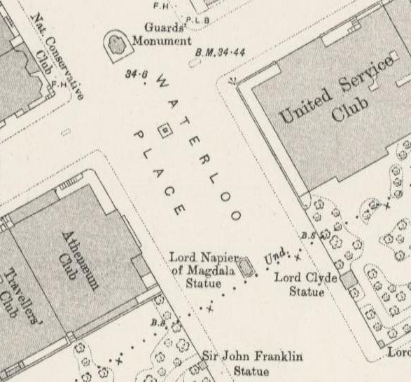
As it is clear to see from the map above, courtesy of the London OS Town Plan, Waterloo Place is surrounded by a plethora of clubs, most likely meeting places for upper class citizens, and is also populated by war monuments and artistic statues, including a memorial to commemorate the Crimean War. One of the clubs visible on the map, the Athenaeum Club, was a clubhouse for gentlemen of the upper middle class, who enjoyed the arts, science, and were known for their artistic accomplishments. It was only in 2002 that the club, which still operates to this day, began to admit female members.

According to the Charles Booth Poverty Map as well, it is obvious that Waterloo Square is in a very wealthy area of London, as if the various sculptures and clubs in the area are not proof enough. On Booth’s charts, both red and orange represent middle class and upper middle class establishments being present, and the overwhelming amount of both colors suggest that Waterloo Place was in the center of a very affluent area. Its close proximity to Piccadilly Circus and the Royal Academy of the Arts also backs up this claim. However, it is interesting to note that on the left side of St. James Square, there is a row of blue dwellings, which indicates that was a smattering of poor families living in the area as well.
Works Cited
Levy, Amy. The Romance of a Shop. Ed. Susan David Bernstein. Canada: Broadview Editions, 2006. p. 135. Print.
Charles Booth Online Archive. Booth Poverty Map and Modern Map. Web. 30 October 2015. http://booth.lse.ac.uk/cgi-bin/do.pl?sub=view_booth_and_barth&args=529583,180350,1,large,0
London – OS Town Plan 1893-6. Web. 30 October 2015. https://mapsengine.google.com/07550989709782409818-08328807677136535917-4/mapview/?authuser=0