Cannon Street and The Man with the Twisted Lip

In The Man with the Twisted Lip, by Sir Arthur Conan DoyleCannon Street is mentioned in the beginning of the story when Holmes is describing his new case to Watson. He describes Neville St. Clair to Watson and what his daily routine looks like. In the story, Holmes tells Watson, “He had no occupation, but was interested in several companies, and went into town as a rule in the morning, returning by the 5.14 from Cannon Street every night” (133). We all know how the story goes. After investigation,  St. Clair is revealed to disguising himself as a beggar due to the simple fact that he made more money begging than any other job. St. Clair’s daily routine consisted of him returning home from Cannon Street. After doing some research about this street, this Sherlock Holmes story ties into the history of Cannon Street.

Screen Shot 2015-11-07 at 2.45.07 PMScreen Shot 2015-11-08 at 5.35.15 PMScreen Shot 2015-11-08 at 5.34.51 PM

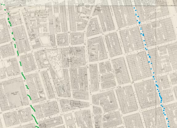
Cannon Street was a poor area of Victorian London. According to Charles Booth’s Poverty Map, Cannon Street is poor. This map also states that this area housed many 18-21 year olds. After researching Old Bailey Proceedings, I found that many crimes were related to burglary. In fact, there are 54 cases listed as theft. Cannon Street was also a road that lead to Cannon Street Station. An area that includes a major transportation station for a city could be very populated. This could also lead to increase in crime. The dominant young-aged civilians that lived on Cannon Street could also play a part in crime.

Screen Shot 2015-11-07 at 2.34.05 PM

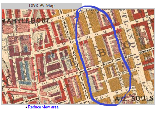
Cannon Street was originally called Candlewick Street. It was named this due to the candle makers who lived there. After them, it became home to drapers, who sell cloth and dry goods. The ancient Roman milestone, now the London Stone, also resides on Cannon Street in the church of St. Swithin. The legend of this stone says that it is so strong and rooted to the earth that even if a car were to hit into it, it would not move. The car would dent before the rock moved. During the Fire of London, the stone was half destroyed. There is now a new, less powerful, stone on top of the old stone to preserve the old stone. In 1866, the Railway Extension opened, creating a connection with Charing Cross and London Bridge. There is a signal box at the entrance of Cannon Street that extends across the entire bridge. There is also a hotel on Cannon Street which has visually appealing architecture.

Screen Shot 2015-11-08 at 5.32.16 PMScreen Shot 2015-11-08 at 5.33.00 PM


Bibliography

  • Locating London’s Past, The Old Bailey Proceedings, 1700-1814, Theft, Cannon Street.
  • http://www2.warwick.ac.uk/fac/arts/english/currentstudents/undergraduate/modules/fulllist/special/endsandbeginnings/twistedlip.pdf
  • Walter Thornbury, ‘Cannon Street’, in Old and New London: Volume 1 (London, 1878), pp. 544-550 http://www.british-history.ac.uk/old-new-london/vol1/pp544-550 [accessed 8 November 2015].
  • http://booth.lse.ac.uk/cgi-bin/do.pl?sub=view_booth_and_barth&args=532366,180940,1,large,0

London Locations – 49 Great Russell Street, Museum Tavern, Alpha Inn

Figure 1: View of 49 Great Russell Street on Victorian Google MapsScreen Shot 2015-11-08 at 1.05.29 PM

Figure 2: Google Maps screenshot of Museum Tavern as of today Screen Shot 2015-11-08 at 1.06.44 PM


Figure 3: Charles Booth Online Archive screenshot of 49 Great Russell StreetScreen Shot 2015-11-08 at 1.23.20 PMScreen Shot 2015-11-07 at 3.58.12 PM


From what we know about the 49 Great Russell Street, or the Alpha Inn, (now known as the Museum Tavern because of the popularity from museum goers) from the Blue Carbuncle is that Henry Baker had purchased the goose, unknowing of the precious gem inside, from the Alpha Inn near the British Museum. From the Charles Booth Online Archive (Figure 3) we can tell that everywhere around the museum was middle to upper middle class, telling us that everyone living around there was very comfortable financially. This tells us about Henry Baker, knowing that he could afford to buy a (probably) pricey goose from the Inn. The goose must have been a well kept one, or it’s original seller must have been a middle class person to have the ability to sell in that area, around the upper class people.  According to an article on the British History website, a very wealthy and talented artist and scientist Benjamin Wilson lived on Great Russell Street for the ending of his life in the 1700s, giving us insight that significant people who can afford to live on this street have been doing so for a hundred years (Nos. 55 and 56, Great Queen Street). From a court preceding in Old Bailey’s Archive made in 1811, John Jones was a poulterer on Great Russell Street who had some product stolen from him (“John Jones, theft”). This is very interesting information because in the original Holmes story, a piece of poultry was sold on that street, giving the readers information that Great Russell Street is a popular market, and one good enough to steal from. This is important because Sir. Arthur Conan Doyle wanted to put Sherlock into current context so his readers could relate to the story, and give Sherlock a more real feel.


Works Cited

“John Jones, Theft, October 30th 1811 (t18111030-79).” Old Bailey Proceedings Online Web. November 8. 2015. http://www.oldbaileyonline.org/browse.jsp?id=t18111030-79&div=t18111030-79&terms=+Great%20+Russell%20+Street%20#highlight

‘Nos. 55 and 56, Great Queen Street.’ Survey of London: Volume 5, St Giles-in-The-Fields, Pt II. Ed. W Edward Riley and Laurence Gomme. London: London County Council, 1914. 42-58. British History Online. Web. 6 November 2015. http://www.british-history.ac.uk/survey-london/vol5/pt2/pp42-58.

Tottenham Court Road

In “The Adventures of The Blue Carbuncle,” Holmes relates the current circumstances of his latest mystery to Watson. The constable, Peterson, retrieved the goose that laid the sparkling gem that the narrative revolves around.

Screen Shot 2015-11-07 at 4.09.54 PMScreen Shot 2015-11-07 at 4.09.03 PM

Peterson witnessed a staggering man on the corner of Goodge Street and Tottenham Court Road who gets accosted by a gang of ruffians. The muggers, as well as the owner of the goose, are scared off by the sound of breaking glass and a man in an official looking uniform, according to Holmes, but not before the goose is left abandoned and the opportunistic constable takes home a fresh bird for dinner (Doyle).

According to British History Online, this street was not a home of dukes or duchesses but the “prosaic and work-a-day world” that one would find more pawnbrokers and “gin palaces” than clubs or churches (Walford). Not all of Tottenham Court Road was dangerous, however, but as the “Blue Carbuncle” tells us. The street was surrounded by tenements and low and squalid thoroughfares. The main street was middle class and had some “fine streets and handsome squares” along with a few public buildings or private mansions (Walford).

To attest to the reputation told to us by British History Online, we only have to look at the many accounts in Old Bailey Online. To put in Goodge Street or Tottenham Court Road brings up scores of highway robberies, murders, and assaults throughout the Victorian Age. Tottenham Court Road seems to have been a thriving business district during the daytime but not a place one would like to walk the goose at night. A Michael Ranton committed highway robbery on the 16th of October 1782. This is one of many acts of larceny that occurred on a middle class section of London on a nightly basis.

According to Charles Booth online Archive, this section of London was a mix of middle-class, well to do citizens, but surrounded by poor neighborhoods. In the context of our story, it serves as the perfect location for a robbery on a man carrying a goose home to occur.

Screen Shot 2015-11-07 at 5.17.22 PM


Works Cited


Doyle, Sir Arthur Conan. The Adventures of Sherlock Holmes. The Adventure of The Blue Carbuncle. Web. 7 November 2015. http://ignisart.com/camdenhouse/canon/blue.htm


Edward Walford, ‘Tottenham Court Road’, in Old and New London: Volume 4 (London, 1878), pp. 467-480 http://www.british-history.ac.uk/old-new-london/vol4/pp467-480. Web. 8 November 2015. http://www.british-history.ac.uk/old-new-london/vol4/pp467-480.


“Michael Ranton”, Violent Theft, October 1782 (t17821016-5).” Old Bailey Proceedings Online. Web. 8 November 2015.

http://www.oldbaileyonline.org/browse.jsp?id=t17821016-5&div=t17821016-5&terms=Tottenham|Court|Road|or|Goodge|Street#highlight


Charles Booth Online Archive. Web. 8 November 2015. http://booth.lse.ac.uk/cgi-bin/do.pl?sub=view_booth_and_barth&args=529432,181653,1,large,0

Harley Street

baker and harley
Harley Street and Baker Street on OS map of London from 1893-96 (Harley Street in blue)
“Our footfalls rang out crisply and loudly as we swung through the doctors’ quarter, Wimpole Street, Harley Street.. , and so through Wigmore Street into Oxford Street. In a quarter of an hour we were in Bloomsbury at the Alpha Inn, which is …which runs down into Holborn”.

Sherlock holmes and Watson in the story The Blue Carbuncle walk through the streets of London on their way to the Alpha Inn to follow up a lead into the case of the stolen blue carbuncles. Harley Street is parallel to Baker street (see on OS map above), and not far so the route, they walked through in the story, makes sense. However, when following this route on the map it does not match up. Harley Street does not meet with Wigmore on the way to Holborn, as can be seen on the OS map of London from 1869-80 below

Sherlocks walk jpeg

 Red line- Baker Street, Yellow line- Wimpole Street, Green line- Harley Street, Blue line- Wigmore Street, Purple dotted line- the route Holmes took. The end of the blue line is where Wigmore Street ends, Cavendish Square begins. Harley flows into Cavendish Square.

In the story they walk from Harley Street to Wigmore Street which is possible only if they turn counter to their next destination Oxford Street towards Holborn. The point is that Conan Doyle wanted to include Harley and Wimpole streets in the story even if it doesn’t make sense for them to walk that way, especially when in a rush in a very cold night.

Harley Street is specified in the story as the doctors’ quarter. it was, and still is, regarded as the quarter of the best doctors:

 “White Mason gazed at my friend as the little village practitioner looks at the Harley Street specialist who by a word can solve the difficulties that perplex him” (the Valley of Fear Chapter 4 ).

Harley Street is also discussed in the story The Resident Patient:

” In March of that year Dr. Moore Agar, of Harley Street … gave positive injunctions that the famous private agent lay aside all his cases and surrender himself to complete rest if he wished to avert an absolute breakdown.”

Here again a Harley Street doctor is mentioned as an indication to a high quality care given to Sherlock Holmes.

The map in Charles Booth Poverty map shows that Harley street residents were from Upper-middle and Upper classes, Wealthy.

Booth-wealth mapScreen Shot 2015-11-07 at 3.58.12 PM

Baker Street residents, according to Booth Poverty Map are designated in red-  middle class, Well-to-do . So Harley Street residents were considered of a higher class then those on Baker Street.

Walter Thornbury in his book Old and New London: Volume 2 supports the portrayal of Harley street: “The doctors now swarm in Cavendish Square, Harley Street, Wimpole Street….” referring to the migration of practitioners from Finsbury Park area to the Harley street area in mid 19th century. He continues: “When the doctors and surgeons thus swarmed in the Finsbury district, the City and its adjacent districts were largely inhabited by wealthy families, that have now also migrated westward, as their doctors naturally have.

Sherlock Holmes in his walks in upper class districts, and in him being treated by  upper class doctors maybe positioned as a close member to the upper classes. In the British class based society this position might be necessary to shape Holmes’ character as respected and trusted.


St. John’s Wood Assingment #8

St. John’s Wood is an entire district in London composed of very affluent neighborhoods. In Sherlock’s “Scandal In Bohemia” Irene Adler, the only woman who is able to deceive Holme’s, lives in St. John’s Wood.

Screen Shot 2015-11-07 at 11.28.08 AM

Screen Shot 2015-11-06 at 5.26.16 PM


Using Victorian Google Maps I learned that St. John’s Wood is actually a very big area and it is characterized by many houses, proving to be a wealthy district.

According to Forbes magazine, St. John’s Wood (with the area post code NW8) is the fifth most expensive neighborhood in London based on the average home price in 2007.

In the “Scandal of Bohemia” Irene has a photograph that Holmes needs to get back for his client. Just as he was about to cleverly cheat her into showing him where she had it hidden, Irene outsmarts Holmes. She took the photograph with her and ran off to another country with her new husband. The fact that Irene lived in such a wealthy area is important to the plot because it suggests that independence and wealth contributes to her cleverness.

Using Old Bailey’s Locating London I was able to search for crimes committed in St. John’s Wood. I found one in particular that was very interesting of a married couple, William and Elizabeth Board who were found guilty of coining and given death penalties (“William & Elizabeth Board, Coining”). Counterfeit money was a popular crime in Victorian London with very serious punishments. The irony is that crimes like these occurred in wealthy neighborhoods where people did not need the money, but instead craved the “high” of committing the crime. In todays time a perfect example is celebrities caught stealing, they have the means to get what they desire  but it’s the adrenaline they’re after.

Screen Shot 2015-11-07 at 3.02.30 PM                    Screen Shot 2015-11-07 at 3.58.12 PM

Using “Charles Booth Online Archive” I was able to search for St. John’s Wood and with a color key determine the economic status of the neighborhood. For the most part, everything in St. John’s Wood is color red and yellow signifying middle class and the wealthy. An important theme in all of Holme’s stories is “class.” By knowing that class in London was of so much importance and the wealthier you were, the higher your social status was, we are able to infer that  Irene Adler who lived in St. John’s Wood was not also wealthy, but also of a high social class. After Holmes was outsmarted by Irene Adler, he began to change his perception of women and gradually accept that women could be “good thinkers” as well.

Works Cited

Donnelly, Sue, and Judith Etherton. “Booth Poverty Map & Modern Map (Charles Booth  OnlineArchive).” Booth Poverty Map & Modern Map (Charles Booth Online Archive). London School of Economics & Political Science, n.d. Web. 07 Nov. 2015.

“Google Maps Engine: Map View.” Google Maps Engine: Map View. National Library of Scotland, n.d. Web. 07 Nov. 2015.

Olson, Parmy. “In Pictures: London’s Most Expensive Postcodes.” Forbes. Forbes Magazine, 12 Dec. 2012. Web. 07 Nov. 2015.

“William & Elizabeth Board, Coining, Februrary 1805 (t18050220-79).” Old Bailey Proceedings Online. Web. 6 November 2015.


Victorian London Locations: Threadneedle Street

Threadneedle Street is mentioned in The Man with the Twisted Lip, where Neville St. Clair, disguised as Hugh Boone, performs his beggary. Boone sits, “Some little distance down Threadneedle Street, upon the left-hand side,” just outside the opium den (Doyle 5). This is where Mrs. St. Clair spots her husband flailing from a window. Before this interruption she walks skeptically, “glancing about in the hope of seeing a cab, as she did not like the neighbourhood in which she found herself” (Doyle 4). The story gives the impression that this was an impoverish and faulty area.

A historical account of Threadneedle St. recalls the area was occupied by “cripples on go-carts who haunted the neighbourhood” (Thornbury, “Threadneedle Street”). This alludes to Doyle’s story quite well considering St. Clair portrayed Boone as a cripple.

Taken from the “Charles Booth Online Archive,” the area surrounding Threadneedle Street was classified as poor. (See Poverty Classification Key.)

It’s hard to see clearly, but the street is located mid photo, above St. Michael. View the “Booth Archive” page, here.

Screen Shot 2015-11-06 at 3.58.04 PMScreen Shot 2015-11-06 at 3.23.42 PMHere’s a better glimpse of Threadneedle Street from 2000.

Screen Shot 2015-11-06 at 3.23.58 PM

The crime and poverty as described in The Twisted Lip and the Poverty Classification (Booth Archive) of Threadneedle St. correspond well.

So, how much crime actually surrounded Threadneedle Street based off of the story in The Twisted Lip? Using “Old Bailey Online,” I was able to find multiple accounts of grand larceny, murder and theft in the Threadneedle St. area. From the Conviction of Henry Harrison, Mr. Harrison, escaped prisoner, hid for sometime in the home of a Mr. Garway. As it is mentioned, “He takes a Lodging at Mr. Garway’s in Threadneedle-street, on the twenty third day of December, and there he continued till about the first of January” (“Henry Harrison, Killing”). Mr. Harrison was a convicted murderer. Pretty profound!

A particular case involved several pieces of stolen clothing by a man named Joseph Johnson, carrying “the Goods of William Savage” from London’s Lombard Street to Threadneedle Street (“Joseph Johnson, Theft”). Other cases involved pickpocketing, and violent encounters. A constable was charged with Edward Lynch, where on “Threadneedle street, [the prisoner] drew a knife upon the prosecutor” and made attempts at the constable as well (“EDWARD LYNCH, Theft”).

Charles Rice, who had stolen innumerable goods, was spotted on Threadneedle Street. Once, by a man named Thomas Edwards who “was coming up Threadneedle-street, when [Rice] was in custody,” and another time by Alexander Barland who saw [Rice] heading towards the “Edinborough coffee-house” (“CHARLES RICE, Theft”).

Edinborough wasn’t the only coffee-house mentioned near Threadneedle St. From “British Histories” I learned of the “North and South American Coffee House (formerly situated in Threadneedle Street)” (Thornbury, “Threadneedle Street”). There was also the Baltic Coffee House, where merchants and brokers occupied their time. It was described as a “rendezvous of tallow, oil, hemp, and seed merchants” (Thornbury, “Threadneedle Street”)

Threadneedle was also the site of the French Protestant Church where red pavement lined the streets. The findings of pavement are rather remarkable and exceptionally crafted (Thornbury, “Threadneedle Street”). It goes to show that Threadneedle St. was not solely defined by theft and poverty but the site of pleasant coffee-houses and decorated pavement.

The Threadneedle Street Pavements:

fig179 fig180

Works Cited

“Joseph Johnson, Theft, October 1720 (t17201012-3).”  Old Bailey Proceedings Online.  Web. 6 November 2015. <http://www.oldbaileyonline.org/browse.jsp?id=t17201012-3-defend38&div=t17201012-3#highlight>

“Henry Harrison, Killing, April 1692 (t16920406-1).” Old Bailey Proceedings Online. Web. 7 November 2015. <http://www.oldbaileyonline.org/browse.jsp?id=t16920406-1&div=t16920406-1&terms=+threadneedle%20+street%20#highlight>

“CHARLES RICE, Theft, September 1785 (t17850914-125).” Old Bailey Proceedings Online. Web. 7 November 2015. <http://www.oldbaileyonline.org/browse.jsp?id=t17850914-125&div=t17850914-125&terms=+threadneedle%20+street%20#highlight>

“EDWARD LYNCH, Theft, September 1776 (t17760911-34).” Old Bailey Proceedings Online. Web. 7 November 2015. <http://www.oldbaileyonline.org/browse.jsp?id=t17760911-34&div=t17760911-34&terms=+threadneedle%20+street%20#highlight>

Thornbury, Walter. “Threadneedle Street.” Old and New London: Volume 1. London: Cassell, Petter & Galpin, 1878. 531-544. British History Online. Web. 7 November 2015. <http://www.british-history.ac.uk/old-new-london/vol1/pp531-544>

“Plate 50: Threadneedle Street, Pavements.” An Inventory of the Historical Monuments in London, Volume 3, Roman London. London: His Majesty’s Stationery Office, 1928. 50. British History Online. Web. 5 November 2015. <http://www.british-history.ac.uk/rchme/london/vol3/plate-50>

Wigmore Street info complied by Maisie Miller- Assignment # 8 Victorian London Locations

Wigmore Street, from

“The Adventure of the Blue Carbuncle”

Google Maps via London OS Town Plan 1893-1896 
Screen Shot 2015-11-06 at 5.00.51 PM

Modern View

Screen Shot 2015-11-06 at 5.01.23 PM

Wigmore Street is a street in the City of Westminster, in the West End of London. The street runs for about 600 yards parallel and to the north of Oxford Street between Portman Square to the west and Cavendish Square to the east. In Victorian London, Wigmore Street was one of shops, homes, and varying socioeconomic status. For Sherlock Holmes, and John H. Watson, Wigmore Street is merley one you pass by, to get to the next one, as dictated from Sir Arthur Conan Doyles “The Adventure of the Blue Carbuncle”,

“Wimpole Street, Harley Street, and so through Wigmore Street into Oxford Street. In a quarter of an hour we were in Bloomsbury at the Alpha Inn, which is a small public-house at the corner of one of the streets which runs down into Holborn. “

On further investigation, I discovered that Wigmore Street remains largely overlooked, a mere passing street of little interest. Wigmore seems average now, in present day, and it seems that it was average in the setting of Sherlock. During the Victorian era, according to Booth Poverty Map’s, the middle class faced the street itself, while clusters of higher class would surround the blocks. Interestingly enough, small lines of blue and black even, indicated the poor and low class were close by too, impressively close to the wealthy even.

 Screen Shot 2015-11-06 at 5.27.01 PM Screen Shot 2015-11-06 at 5.26.44 PMEven with the varying levels of class, Wigmore remained somewhat stagnant and had low crime. This could be related to the police departments presence no more than a block away. However, when crime was committed it was usually theft according to court records from Old Bailey Online as well as Locating London. The theft is usually small, for example

SUSANNAH LACY was indicted for stealing, on the 27th of July , 33 yards of ribbon, value 5 s. , the goods of William Debenham and Thomas Clark .

WILLIAM DEBENHAM . I am in partnership with Thomas Clark ; we are haberdashers , and live in Wigmore-street, Cavendish-square . On the 27th of July, about two o’clock in the afternoon, Barnes called me, and said the prisoner had taken a piece of ribbon. I took her into the counting-house, and she produced it from her handkerchief.

FRANCIS BARNES . I am apprentice to the prosecutors. I saw the prisoner take the ribbon out of the drawer, and put it into her handkerchief.

(Property produced and sworn to.) Prisoner. Distress led me to it.GUILTY . Aged 44.Confined Six Months .Third Middlesex Jury, before Mr. Recorder.

She stole ribbon, and indicates that stress led her to doing so. There is no apparent drama or excitement, like I hoped, it seems on Wigmore Street. Due to it’s close proximity to Oxford Street, I looked into the London Eye website’s Oxford Street subcategory. There was not much information there. Highlighted in the British  History Online, are seemingly the wills of the wealthy who died in the Victorian Era, and either had residence on Wigmore Street or investment.

Screen Shot 2015-11-06 at 6.02.26 PM

Wigmore Street remains one of little interest; to Holmes, as well as historians.

 Works Cited
“Booth Poverty Map & Modern Map (Charles Booth Online Archive).” Booth Poverty Map & Modern Map (Charles Booth Online Archive). N.p., n.d. Web. 06 Nov. 2015. <http://booth.lse.ac.uk/cgi-bin/do.pl?sub=view_booth_and_barth&args=528400%2C181259%2C1%2Clarge%2C0>.
“Google Maps Engine: Map View.” Google Maps Engine: Map View. N.p., n.d. Web. 06 Nov. 2015. <https://mapsengine.google.com/07550989709782409818-08328807677136535917-4/mapview/?authuser=0>.
“The Historical Eye.” London 1896. N.p., n.d. Web. 06 Nov. 2015. <http://historicaleye.com/1896%20London%20then%20and%20now/index.html>.
“Home | LOCATING LONDON’S PAST.” Home | LOCATING LONDON’S PAST. N.p., n.d. Web. 06 Nov. 2015. <http://locatinglondon.org/>.
“The Proceedings of the Old Bailey.” Old Bailey Online. N.p., n.d. Web. 06 Nov. 2015. <http://www.oldbaileyonline.org/>.
“Search.” Search. N.p., n.d. Web. 06 Nov. 2015. <http://www.british-history.ac.uk/search/period/18th-century?query=%22wigmore+street%22&title=>.

London Road

In “The Man With the Twisted Lip,” London Road is briefly mentioned as Sherlock and Watson begin their dash to finally solve the mystery of Mr. Neville St. Clair’s disappearance. Upon further research, I learned some interesting facts about the road that had little significance in the actual Sherlock Holmes story. Unfortunately, there are over twenty roads called “London Road,” just in the city of London, alone! So many of the facts that I saw were not entirely accurate due to the inability to distinguish between multiple roads. Since many of the websites are not specifically based around Victorian London, it was more difficult to find the correct road.London Road in text

By using the Old Bailey Proceedings through Locating London, I was able to find that there were not many crimes committed on the road, but of the ten crimes that came up in the search results, five of them were highway robberies, and three involved animal theft. The first result was of a man names James Coates, who viciously stole a diamond ring from Mrs. Elizabeth Atley. He was sentenced to death for this crime (“James Coates, highway robbery”). I also learned that the London Road in Ipswich, not in London, is apparently site of the flat of Steve Wright, who murdered five women in 2006, an event about which a movie and a musical were written (both called London Road).

While looking at the OS Town Plan of Victorian London, I can tell that London Road has not changed much, and is still a major road in the city. Much of the information about London Road on British Histories contained information about religion. It was interesting because several of the articles were about religions that do not dominate London, such as Judaism and Islam. There are also many bits of information about monuments and buildings on the road.

London Road, Google MapsLondon Road Google Earth

The Charles Booth website offered the most useful and accurate information, despite having the worst design of any of sites. The website shows a map of London and color codes each street based on economic class. It shows London Road in pink, which means that the average economic state of people on London Road back in Victorian London was “Fairly comfortable.”

London Road Charles Booth

Works Cited

Doyle, Arthur Conan. London: Strand, 1891. Short Stories: The Man With The               Twisted Lip by Arthur Conan Doyle. East of the Web. Web. 6 Nov. 2015.                 <http://www.eastoftheweb.com/short-stories/UBooks/TwisLip.shtml>.

“Search.” British Histories. University of London, n.d. Web. 6 Nov. 2015.                        <http://www.british-history.ac.uk/search?query=%22London+Road%22>.

“Booth Poverty Map & Modern Map (Charles Booth Online Archive).”Booth                   Poverty Map & Modern Map (Charles Booth Online Archive). London                   School of Economics and Political Science, n.d. Web. 6 Nov. 2015.                         <http://booth.lse.ac.uk/cgi-bin/do.pl?                                                                             sub=view_booth_and_barth&args=531720%2C179260%2C1%2Clarge%2C0>.

“James Coates, highway robbery. 15 January 1702 (t17070115-7).” Old Bailey                Proceedings Online. Web. 6 November 2015.                                                                  http://www.oldbaileyonline.org/browse.jsp?id=t17070115-                                        7&div=t17070115-7&terms=+London%20+Road%20#highlight

Old Bailey Proceedings

Victorian Google Maps

Oxford Street; “The Adventure of Blue Carbuncle”

This is Oxford Street, London. Picture from Google Maps


Screen Shot 2015-11-06 at 12.31.22 PM

There is no doubt that Sherlock Holmes knows his way around Victorian London. In “The Adventure of Blue Carbuncle”  Sherlock and his trusty companion, Watson, travel to the one of the market places that branch off of Oxford Street. Such market places were very common on Oxford Street during this era. Oxford Market was one of the largest markets on the street. This particular market attracted both rich and poor due to the merchandise it had to offer. Oxford Street according to records from the Charles Booth archive was predominately middle class (indicated by red on the map below.) However, areas surround the street had both upper class communities (yellow) and lower class dwellings (blue.) For this reason it is not surprising that the markets attracted various classes of society. Screen Shot 2015-11-06 at 12.54.32 PM

With the poor and wealthy living so closely together it came to no surprise that the most common crime that occurred in this area was grand larceny/burglary/robbery/shoplifting. This is evident in “The Adventure of  Blue Carbuncle” because the man’s goose was stolen, then was used as a disguise to carry a precious gem, which was also stolen. The accuracy of historical evidence/facts (discovered on the Old Bailey archive) alines with the crime within the fictional Sherlock Holmes stories. With some further digging, I found that such Geese sales were common (especially around Christmas, which is the time in which the adventure takes place) and that animal robbery became a large issue within this region. Other crimes of historical record that are also evident with the Holmes story is fraud, deception and gambling. This is seen with the man whom sells the geese at the market place. He will only give Holmes information regarding his stock and sales when Holmes places a bet for money. Holmes uses his own deception to trick the sales man into giving him information like what he assumes is true regarding the goose and it’s origin. Thus, the plot and story line make sense because it is historically accurate. Another clue to the conditions and characteristics of this area and salesman is the man’s poverty is displayed by the clothing that he wears. He is dressed very different from Holmes and Watson who are members of the upper/middle class. His lack of wealth could easily be seen as a reason for his actions and gambling nature.

The historical attributes of Oxford Street from the Victorian era is very important in the Holmes stories. By looking at the streets history it is easy to make connects to Sherlocks adventures and assume the background stories of the character that Holmes encounters in certain regions, such as the market place. Personally, this research has helped me further characterize certain individuals within the stories. It provides more insight as to why peoples actions (stealing, lying and deception) were as presented. The poor robbed from the rich because of their poverty and even robbed from each other; as seen with the robbery of the goose. This historical research has helped answer my questions as to why the incidents with the adventures of Sherlock Holmes may have taken place.

(Works cited, links within article to webpage)

Victorian London Locations (The London Bridge)

The London Bridge was created because many people were inconvenienced by not having easy access over the Thames River (The river the bridge now crosses.) Previous bridges were made across the river, but they were made out of wood, which eventually caught fire and burned down. The construction of the London Bridge took six years to complete. ” It was designed by John Rennie, a Scottish Engineer, begun in 1825 under the superintendence of his sons, Sir John and George Rennie, and completed in 1831″ (London Bridge). The cost to make the entire bridge was £2,000,000 which is equivalent to $3,043,300. If you take in consideration that this bridge was built in the 1800’s, you’ll come to the realization that this bridge was highly expensive to construct. The bridge 928 feet long and 54 feet broad and is help up by five granite arches. These granite arches have a span of one hundred and fifty-two feet. An interesting fact is that the lamp posts on the bridge are made of iron from French Canons which were captured in the Peninsular War. More recently, the expanded the bridge in width and it is now 65 feet wide. It is calculated that about 22,000 vehicles and about 110,000 pedestrians cross the bridge every single week. This shows the importance of this bridge to the many people who live in London.

In the Sherlock Holmes story, The Man with the Twisted Lip, the London Bridge was mentioned when John Watson was describing how to get the opium den. “Upper Swandam Lane is a vile alley lurking behind the high wharves which line the north side of the river to the east of London Bridge. Between a slop-shop and a gin-shop, approached by a steep flight of steps leading down to a black gap like the mouth of a cave, I found the den of which I was in search” (Doyle). For some reason, in the context of the story, it seems to make the bridge mysterious and almost creepy. I think it seems like that because it’s so close to the opium den and the author also used words like “lurking” to describe the alley near the London Bridge. Besides that description, I don’t see any other mention of the London Bridge in this Holmes story.

Citations:

Doyle, Arthur Conan. The Man with the Twisted Lip. London: Penguin, 1995. Print.

“London Bridge.” London Bridge. George Landow, 10 Oct. 2001. Web. 05 Nov. 2015.

Screenshot (14)Screenshot (13)  Screenshot (15)