A Holmes map by Courtney Kiesecker and Heather Ryan
url: https://a.tiles.mapbox.com/v4/court-kie.npa8nlbk/page.html?access_token=pk.eyJ1IjoiY291cnQta2llIiwiYSI6ImNpZzJsMjBndjFlOG10M2t3M3A5Y2owamMifQ.kDjZPet-JcmZ8NWTG1dJ-g#15/51.5079/-0.1054

A Holmes map by Courtney Kiesecker and Heather Ryan
url: https://a.tiles.mapbox.com/v4/court-kie.npa8nlbk/page.html?access_token=pk.eyJ1IjoiY291cnQta2llIiwiYSI6ImNpZzJsMjBndjFlOG10M2t3M3A5Y2owamMifQ.kDjZPet-JcmZ8NWTG1dJ-g#15/51.5079/-0.1054
Scandal in Bohemia Project By Daniela Velez, Katie Vyas, Dea Barbieri (Edgware Road Group)
If having trouble viewing, click the here.
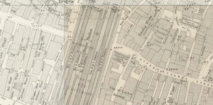
In Sir Arthur Conan Doyle’s story “The Man with the Twisted Lip,” Cannon Street Station in London gets a quick mention by Sherlock Holmes. In the story, Holmes mentions that Neville St. Clair had a routine of “returning by the 5.14 from Cannon Street every night” (Doyle 133). Cannon Street Station is a real train stop, which still operates in London today. The station opened in 1866 and was a widely used station in London at the time. There was also a hotel at the station where “arrangements were made for reception of about 20,000,000 passengers yearly” (Thornbury). At the time “The Man with the Twisted Lip” was published, the station was just under thirty years old. Despite the fact that St. Clair is understood to be relatively well off, according to the Charles Booth Online Archive, much of the area nearby the station lived in poverty. Also, St. Clair may travel through Cannon Street, because it is a poorer area, making his charade as a beggar more believable. He could very easily blend in with those more in need than he. According to the Old Bailey online, most crimes that happened on Cannon Street were some form of robbery or burglary, although there are occasional cases of murder, but most cases that took place in the station had to do with some form of theft. This is a strong connection to St. Clair’s occupation of the opium den, as opium dens were often times connected with crime. The cases of theft may make Cannon Street a metaphor for the fact that St. Clair poses as a beggar. In a sense, he is stealing from those more in need than he. This plays into the themes of deception and poverty, which are very common themes in Victorian literature including the stories of Holmes.
Works Cited
Booth, Charles. “Booth Poverty Map (Charles Booth Online Archive).” Booth Poverty Map (Charles Booth Online Archive). LSE Library, n.d. Web. 19 Oct. 2015.
Doyle, Arthur Conan. “The Man with the Twisted Lip.” The Adventures of Sherlock Holmes. London: Penguin, 1995. 133. Print.
“The Proceedings of the Old Bailey.” Old Bailey Online. N.p., n.d. Web. 19 Oct. 2015.
Thornbury, Walter. ‘Cannon Street.’ Old and New London: Volume 1. London: Cassell, Petter & Galpin, 1878. 544-550. British History Online. Web. 14 October 2015. http://www.british-history.ac.uk/old-new-london/vol1/pp544-550.

In Sir Arthur Conan Doyle’s short Sherlock Holmes story, “The Man with the Twisted Lip”, the reader is introduced to the eerie and narrow Upper Swandam Lane based on its realistic counterpart, Swan Lane.
Upper Swamdam Lane, according to Dr. Watson is “a vile alley lurking behind the high wharves which line the north side of the river to the east of London Bridge. Between a slop-shop and a gin-shop, approached by a steep flight of steps leading down to a black gap like the mouth of a cave, I found the den of which I was in search” (Doyle 128). East London, as we have consistently read about, is not a nest that the rich are wont to reside. Depicted on the map above, Swan Lane looks as though it is hidden, making it a back-alley to put the poor of London with only a single entrance from Thames Street. Because of Swan Lane’s location in London, being relatively near the Thames and surrounded by various wharves and piers, the incoming trafficking of opium made Swan Lane a perfect area for Doyle to fictionalize his pivotal plot point of the opium den.
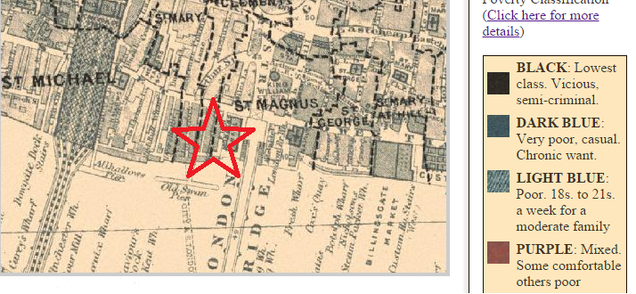
From The Charles Booth Online Poverty Archive, Swan Lane, located inside the star on the above image, is light blue in color, indicating the impoverished living in the area. Due to the poor, seemingly closed off street, and its proximity to London Bridge and Cannon Street Station, Doyle’s character Neville St. Clair is able to embody a beggar and use the opium den as a changing room from one facet of life into another. The opium den reeling in the rich to a poverty-stricken area is a perfect place to cross one social class border into another. Especially when the rich are emptying their pockets to quell their opium addictions.
All in all, the historical data from the Booth Online Poverty Archive and the location of Swan Lane bring to life Doyle’s depiction of Upper Swandam Lane, as well as accurately expose a pocketed opium den. Through this, Doyle is able expose corruption of social class and addiction through a narrow port area.
_________________
Works Cited:
Doyle, Arthur Conan. The Man with the Twisted Lip. N.p.: n.p., n.d. Print.
“Booth Poverty Map & Modern Map (Charles Booth Online Archive).” Booth Poverty Map & Modern Map (Charles Booth Online Archive). N.p., n.d. Web. 18 Oct. 2015.
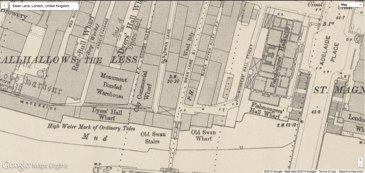
Upper Swandom Lane, or Swan Lane as it was actually known, is the location of the opium den in the Sherlock Holmes story, “The Man with the Twisted Lip” by Sir Arthur Conan Doyle. It is from this den that Neville St. Clair supposedly disappears. It is the last place that his wife sees him and foul play is suspected by his family, the police, and Holmes. Eventually it is revealed that St. Clair was not missing at all, simply living his double life as a successful beggar from his base above the opium den.
In real life, Swan Lane is a street adjacent to London Bridge on the north side of the River Thames. As seen from the Victorian google map, the southern end of the lane juts against the river and is sometimes underwater at high tide. This becomes a plot point in the Holmes story as Mr. St. Clair throws his coat out the window and into the river when he hurriedly transforms into his beggar self. This action leads the police to believe that Neville St. Clair has met a terrible fate.
As can be seen from the Booth Poverty Map of the region, this street was one of the poorest in London. It is little wonder an upstanding citizen disguised as a beggar would make his base here as he would blend in so well with the surrounding socioeconomic environment. No one who knew St. Clair would ever think to look for him amongst the riffraff hanging around the docks.
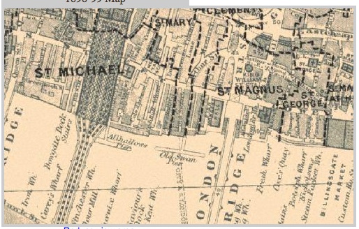
Shown by the black marks on the map, Swan Lake was also a hotbed of criminal activity. It is little wonder then that Dr. Watson runs into Holmes investigating a crime on the street or, as Holmes notes, that it is so common for people to disappear from the very opium den in question.
Doyle, Arthur Conan. The Man with the Twisted Lip. N.p.: n.p., n.d. Print.
“Booth Poverty Map & Modern Map (Charles Booth Online Archive).” Booth Poverty Map & Modern Map (Charles Booth Online Archive). N.p., n.d. Web. 18 Oct. 2015.
For this assignment, I decided to focus on what could possibly be the most important setting in a Sherlock Holmes tale, the West End location of Sherlock Holmes’ home, Baker Street.
Frankly, I’ve never been much of a fan of Arthur Conan Doyle or his works, and all I know about Sherlock Holmes and John Watson is that they are detectives, and their headquarters were located at 221B Baker Street in London. It is for this reason I decided to dig a little deeper into its history, and find out exactly what kind of area it was to live in.
First off, it is seen almost immediately in “A Scandal in Bohemia,” as the tale opens with John Watson paying Holmes a visit at his residence on Baker Street, before they are interrupted by a visitor, who turns out to be the King of Bohemia in disguise, looking for the detective’s assistance in foiling a plot by his vengeful mistress, Irene Adler. Judging by the fact that a king could walk down Baker Street (albeit wearing a mask) at night without being accosted by burglars or the like, this gave me the assumption that Baker Street was not a particularly risky place to live.
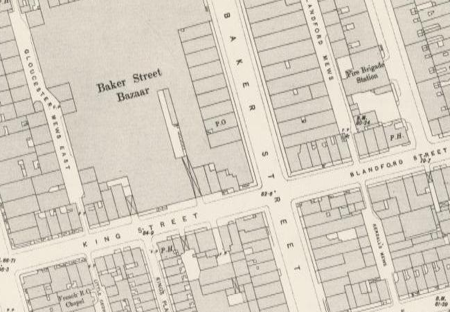
As you can see from the above map from the 1890s, Baker Street was surrounded by many hotels on nearby streets, giving the impression that it was located in an upper class area that was prime for travelers to stay in. There was also a tube station on the street in later years, and was located close to a fire station, which would have made the residents of Baker Street a priority for the fire brigade if there were ever an emergency, judging by their close proximity. There was also the large Baker Street Bazaar, a shopping area where people came to buy food, clothing, and see exhibits, such as an early version of the famed Madame Tussaud’s wax museum. This backs my belief that Baker Street was in a well-to-do area of London, populated by the middle class and the wealthy and with little crime.
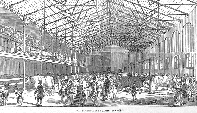
Above: The Baker Street Bazaar, as seen in 1845 for a cattle show.
Truth be told, while searching the Old Bailey Proceedings for news of crimes committed on Baker Street, I could find only victims and other witnesses that gave their addresses as Baker Street, and no crimes that were actually committed there. I thought I may have found an animal theft occurring on Baker Street in an account describing the arrest of one George Welldon, but it turns out that the defendant lived on Lloyd Baker Street in Clerkenwell.
Overall, Baker Street seemed to be located in a safe, upper class community, and today is home to the Sherlock Holmes Museum, located, not surprisingly, at 221B. The legacy of Sherlock Holmes and his living place on Baker Street continues to shape the street’s fame and economic value even today.

“Adventure I. – A Scandal in Bohemia.” The Strand Magazine: Adventures of Sherlock Holmes. Vol. 1. Stanford: Stanford U, 2006. N. pag. The Strand Magazine. Stanford University, 27 Jan. 2006. Web. 17 Oct. 2015. <http://sherlockholmes.stanford.edu/pdf/holmes_01.pdf>.
“London – OS Town Plan 1893-6: Baker Street, London.” Google Maps Engine: Map View. N.p., n.d. Web. 17 Oct. 2015. <https://mapsengine.google.com/07550989709782409818-08328807677136535917-4/mapview/?authuser=0>.
Old Bailey Proceedings Online (www.oldbaileyonline.org, version 7.2, 17 October 2015), October 1768, trial of George Welldon (t17681019-34).
The Sherlock Holmes Museum. Digital image. The Fussiest Eater. Web. 17 Oct. 2015. <http://www.thefussiesteater.com/2012/06/the-sherlock-holmes-museum-221b-baker-st-london/>.
Jackson, Lee. Baker Street Bazaar. Digital image. Victorian London. Nassau Steam Press, n.d. Web. 17 Oct. 2015. <http://www.victorianlondon.org/shops/bazaars.htm>.

Daniela Velez
Prof. Swafford
ENG 493-02
19 October 2015
Mr. & Mrs. Norton on Edgware Road
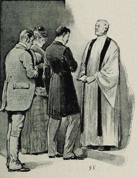
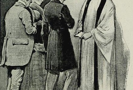
In Sir Arthur Conan Doyle’s short story “A Scandal in Bohemia,” detective Sherlock Holmes is bested by none other than Irene Adler, also referred to as ‘The Woman.’ Towards the end of the tale, Mr. Holmes finds himself swept up in Irene’s shotgun wedding to Mr. Godfrey Norton at the Church of Saint Monica, and becomes a key witness to the legality of their vows due to his ‘lucky appearance’ (9).
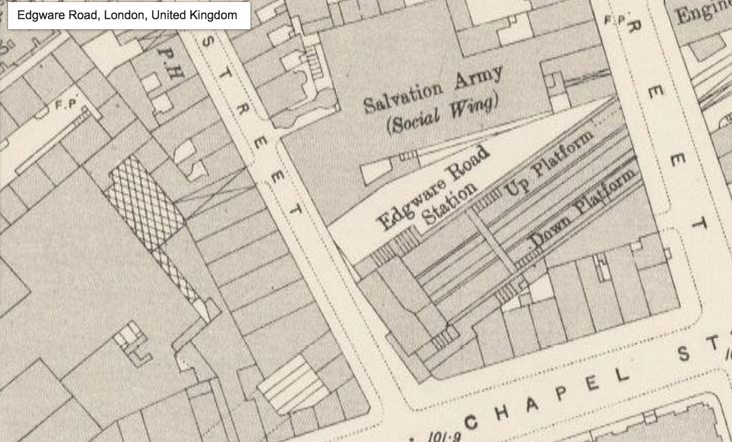
Edgware road was difficult to locate on Victorian Google Maps all that my search result turned up was an image of Edgware Road Station, which is obviously on Edgware Road though the actual name of the street itself does not appear. However, the road does appear on the Charles Booth Online Archive. A majority of the area appears to be middle class/ well to do. This adds to the overall theme of the story, which alludes to class distinctions in not only Victorian London, but the modern world at the time – hence, the prestigious King of Bohemia’s affair with Alder that must be kept hidden even though it occurred years earlier.
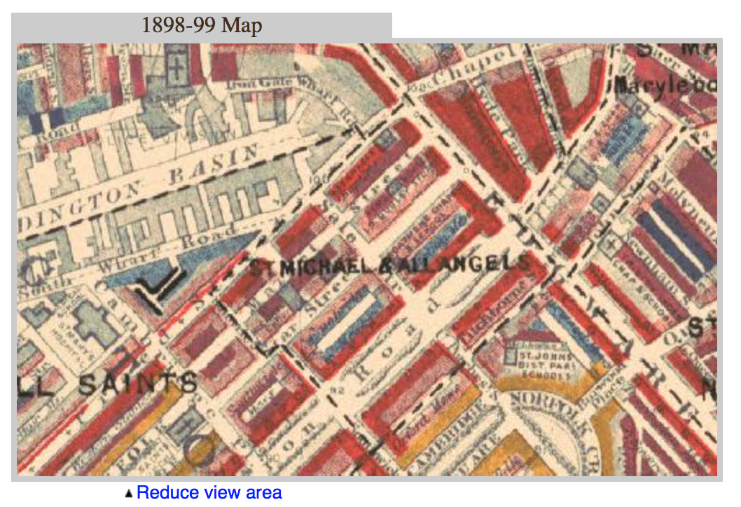
A quick but narrowed search (the years 1881-1901 because that is when Sherlock & Dr. Watson’s adventures on Baker Street took place according to the stories)through the Proceedings of the Old Bailey produced a vibrant array of offenses from coining offenses to murder associated with Edgware Road. The Charles Booth Archive image did show some areas of blue which represents (Lower Class/Poor residents) and little areas of yellow (Upper Class). I believe that the variety of crimes and the sheer number of them could indicate a clash of classes due to wealth inequality, but that is only speculation.