London Road

In “The Man With the Twisted Lip,” London Road is briefly mentioned as Sherlock and Watson begin their dash to finally solve the mystery of Mr. Neville St. Clair’s disappearance. Upon further research, I learned some interesting facts about the road that had little significance in the actual Sherlock Holmes story. Unfortunately, there are over twenty roads called “London Road,” just in the city of London, alone! So many of the facts that I saw were not entirely accurate due to the inability to distinguish between multiple roads. Since many of the websites are not specifically based around Victorian London, it was more difficult to find the correct road.London Road in text

By using the Old Bailey Proceedings through Locating London, I was able to find that there were not many crimes committed on the road, but of the ten crimes that came up in the search results, five of them were highway robberies, and three involved animal theft. The first result was of a man names James Coates, who viciously stole a diamond ring from Mrs. Elizabeth Atley. He was sentenced to death for this crime (“James Coates, highway robbery”). I also learned that the London Road in Ipswich, not in London, is apparently site of the flat of Steve Wright, who murdered five women in 2006, an event about which a movie and a musical were written (both called London Road).

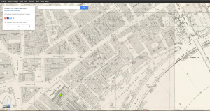
While looking at the OS Town Plan of Victorian London, I can tell that London Road has not changed much, and is still a major road in the city. Much of the information about London Road on British Histories contained information about religion. It was interesting because several of the articles were about religions that do not dominate London, such as Judaism and Islam. There are also many bits of information about monuments and buildings on the road.

London Road, Google MapsLondon Road Google Earth

The Charles Booth website offered the most useful and accurate information, despite having the worst design of any of sites. The website shows a map of London and color codes each street based on economic class. It shows London Road in pink, which means that the average economic state of people on London Road back in Victorian London was “Fairly comfortable.”

London Road Charles Booth

Works Cited

Doyle, Arthur Conan. London: Strand, 1891. Short Stories: The Man With The               Twisted Lip by Arthur Conan Doyle. East of the Web. Web. 6 Nov. 2015.                 <http://www.eastoftheweb.com/short-stories/UBooks/TwisLip.shtml>.

“Search.” British Histories. University of London, n.d. Web. 6 Nov. 2015.                        <http://www.british-history.ac.uk/search?query=%22London+Road%22>.

“Booth Poverty Map & Modern Map (Charles Booth Online Archive).”Booth                   Poverty Map & Modern Map (Charles Booth Online Archive). London                   School of Economics and Political Science, n.d. Web. 6 Nov. 2015.                         <http://booth.lse.ac.uk/cgi-bin/do.pl?                                                                             sub=view_booth_and_barth&args=531720%2C179260%2C1%2Clarge%2C0>.

“James Coates, highway robbery. 15 January 1702 (t17070115-7).” Old Bailey                Proceedings Online. Web. 6 November 2015.                                                                  http://www.oldbaileyonline.org/browse.jsp?id=t17070115-                                        7&div=t17070115-7&terms=+London%20+Road%20#highlight

Old Bailey Proceedings

Victorian Google Maps

Sample Projects

Here are some sample projects from DHM293 last year:

  1. Walking Dead Map: http://walkingdeadgis.weebly.com/
  2. Poverty Across America: http://dhmfinalproject.blogspot.com/
  3. Historic Huguenot Street: http://historichuguenotstreet.tumblr.com/
  4. Mapping SUNY New Paltz: https://sunynpmap.wordpress.com/
  5. Nirvana: Obscurity to Domination: http://nirvanatour.tumblr.com/
  6. Supernatural Locations: https://supernaturallocations.wordpress.com/
  7. Death Eater Studies: https://deatheaterstudies.wordpress.com/

GIS Blog for Piccadilly Circus


Screen Shot 2014-11-09 at 7.50.00 PM

In the Sherlock Holmes stories this is where John Watson hears about Sherlock for the first time as he is looking for a flatmate to move in with. Gaining insight from the Historical Eye webpage I learned a lot about this area in the past and how it is like today. One of the main attractions of Piccadilly Circus is the Burlington house, which still remains today the home of the Royal Academy as it did during Victorian times. A site for entertainment in 1812 was the Egyptian Hall which is no longer there today. The area in general was a place for shopping and entertainment. The London Pavillion was a variety theatre which was very popular during the 1800’s. In the middle of Piccadilly Circus still remains the bronze Shaftesbury Memorial fountain made by Alfred Gilbert.  The Historical Eye gave a very brief overview of the area, but it was helpful for finding more information because I knew what to look for.

I then used the British History online database and found more information about the area along with more pictures. From the pictures, this area seemed very busy and loud. It reminds me of an older version of Times Square in New York, with all the illuminated advertising and signs everywhere. According to the British History online database there was a lot of controversy about these illuminated advertisements because the lights could cause danger to drivers. Laws were created due to the new additions of lights to advertisements. Due the the lavishness of the lights and the types of buildings, it can be concluded that the area was fairly well to do and could afford to have electricity and the means to keep all the storefronts and entertainment businesses up and running.


“Piccadilly to Oxford Street.” Historicaleye.com. N.p., n.d. Web. 09 Nov. 2014.


‘The rebuilding of Piccadilly Circus and the Regent Street Quadrant’, Survey of London: volumes 31 and 32: St James Westminster, Part 2 (1963), pp. 85-100. URL: http://www.british-history.ac.uk/report.aspx?compid=41456&strquery=piccadilly circus Date accessed: 10 November 2014.

GIS: The Final Problem–Vere Street

For my GIS (Geographic Information Systems) project on Sherlock Holmes, I picked Vere Street, where in “The Final Problem,” where Sherlock almost gets hit in the head by a “falling” brick. This is the second attempt on his life in this story. The following quote is the context of the mention of the location within the story: “I kept to the pavement after that, Watson, but as I walked down Vere Street a brick came down from the roof of one of the houses and was shattered to fragments at my feet. I called the police and had the place examined. There were slates and bricks piled up on the roof preparatory to some repairs, and they would have me believe that the wind had toppled over one of these. Of course I knew better, but I could prove nothing.” (The Final Problem)

Screenshot1

I looked on many of the sites listed to provide what the mention of tis street could have to do with the story as a whole. The first data I came across was from the Booth Poverty Map:

Screenshot2

This map shows that in, and around Vere Street there is a wide mixture of people. It almost covers the whole spectrum in this tiny area, going from blue (the poorest) to yellow (the wealthiest). Could this have something to do with the construction going on? Possibly. You would think that the police, though, would have been a little more attentive in such a rich area. Next I looked on Old Bailey Online, but Vere Street yielded no results, so I tried the keyword “brick,” and there was only one result of someone being killed by a brick
Screenshot3

hmmm… not exactly a brick falling from a ledge… But I kept trying on the other databases. Locating London gave me some…weird results. It gave me about 5 pins near Vere Street, but when i clicked on them all it said was “No Results.” alright…..So my last hope for some kind of data was British Histories. I searched Vere Street again…but alas, only one result, which seemed to be a log of a tax collector, or a tax assessment.

Capture

So not much about the cconstruction history, but possibly something can be said here about the wealth of the people here. It seems thaat most of the people renting here are pretty upper to middle class, so it still surprises me that, in this story the police didn’t investigate any further…perhaps somebody paid them not to? That might be what Doyle was trying to get across by using this particular street: that whoever is trying to kill Holmes, has a lot of power.

~ Austin Carpentieri

The Lyceum Theatre

A meeting place between Holmes and the mysterious villains of The Sign of the Four, the Lyceum is a well known and prestigious theatre in Westminster, right off the Strand. The current Lyceum was opened in 1834 after its previous name bearer was destroyed in a fire in 1830- the previous theatre was located just across the street (Lloyd “The Lyceum Theatre, Wellington Street, London – Also known as The Theatre Royal, English Opera House / Royal Lyceum Theatre / English Opera House / Palais de Dance / Mecca Ballroom”). Since its reopening, the theatre has played host to a variety of productions. This pedigree was established during its ownership by one Henry Irving, who produced several adaptations of Shakespeare works during his tenure (starting 1878). It continued to operate through the 20th century, even surviving the Blitz, to play host to bands such as The Clash, Queen, and U2. It closed in 1986 for renovations, then reopened in 1996 to host Jesus Christ, Superstar, and, since 1999, has been the home of London’s production of The Lion King(“Lyceum Theatre London”).

The Wellington Street locale has been a centerpiece of London’s performance arts for almost two centuries, but a cursory inspection of the Old Bailey Archives would show a variety of theft and related crimes surrounding the theatre. A simple example would be the case of the theft of the pocketwatch of one Chahata Jassa, where a pickpocket by the name of James George was able to easily steal the item amid the clutter of the crowd. The theatre, being a prominent landmark, made for an easy meeting place for cases of assault and extortion, like that of John Joyce in August 1844. Simply, like any popular scene, this storied house of drama was party to plenty of it- not all on stage.

lyceum

Citations

Lloyd, Arthur. “The Lyceum Theatre, Wellington Street, London – Also Known as The Theatre Royal, English Opera House / Royal Lyceum Theatre / English Opera House / Palais De Dance / Mecca Ballroom.” The Lyceum Theatre, Wellington Street, London – Also Known as The Theatre Royal, English Opera House / Royal Lyceum Theatre / English Opera House / Palais De Dance / Mecca Ballroom. Web. 9 Nov. 2014.

“Lyceum Theatre London | Lion King Tickets.” Lyceum Theatre London. Web. 9 Nov. 2014. <http://www.lyceumtheatrelondon.org/>.

Traveling to Tottenham: Using GIS to Analyze Locations in Sherlock Holmes

I chose to research Tottenham Court Road because it is mentioned in Sir Arthur Conan Doyle’s The Adventure of the Blue Carbuncle. In the story, Peterson is heading home at night on Tottenham Court Road when he stumbles upon a group of men beating James Ryder. Evidently, Tottenham Court Road is located in an unsafe area.

I began my research by taking screenshots of Tottenham Court Road in Victorian Google Maps. Below is Tottenham Court Road during the both Victorian Era and the present day (“London”).

Screen Shot 2014-11-07 at 6.45.57 PM“British Histories” offered me the most information. At the top of the page is a search bar in which I entered my street name. The search resulted in plethora of publications concerning Tottenham Court Road. The excerpt that I found most valuable on this website revealed that 1878 marked a turn in the lives of many people in London. The author explains that in 1878, poverty was spreading on Tottenham Court Road in Rathbone Place. Walford describes it, “where poverty is almost hopeless” (“Quick”). This helps to explain the violence that Peterson encountered that night he was heading home on Tottenham Court Road. Because of widespread poverty in the area, the men likely attacked James Ryder because they were hungry wanted to eat his goose (and take the blue carbuncle!).

Another site that I found useful in researching Tottenham Court Road was “Old Bailey Online.” It was easy to search for criminal records near or on Tottenham Court Road. The search page allowed me to adjust the time period as well. I searched for records between 1800 and 1901. Almost all of the records from Tottenham Court Road and nearby areas documented theft crimes. Most of them were grand larceny, some of them highway robbery, and a few of them theft from a specified place. One of the records, for example showed that Sarah Crosby stole a shirt, and seven stockings (“The Proceedings”). After viewing the records, I reviewed the situation from The Adventure of the Blue Carbuncle during which the men are attempting to take James Ryder’s goose. With my new knowledge of theft crime on Tottenham Court Road, I realized that it wasn’t uncommon for such situations to occur.

The sites that I found least useful were “Historical Eye,” “Locating London,” and “Charles Booth’s Online Archive.” I was unable to search on “Historical Eye.” On top of that, reading through the site proved to be ineffective because it lacked any information on Tottenham Court Road. “Locating London” turned up only four results even after searching various forms of the street name in 1800 (Ex. Tottenham, Tottenham Ct. Tottenham Court Road). As it turned out, each result led me to the same exact record. The record had nothing to do with Tottenham Court Road, in fact, it only appeared in my search results because the word “Tottenham” appeared on the record once without any context (“Home”). Link to this record: http://www.londonlives.org/browse.jsp?div=NAHOCR70004CR700040070. After an hour of trying to find Tottenham Court Road on the “Charles Booth’s Online Archive” by switching back and forth from Victorian Google Maps to Booth’s map, I still could not locate it. This is unfortunate because Booth’s archive would have been useful for my research considering that it maps poverty.

[Edit Nov. 10th: I now know that there is a search bar on Charles booths online archive. I searched my street name and the following picture of my street revealed that in 1898-99, residents of were living fairly comfortably.]

Screen Shot 2014-11-11 at 7.12.45 AM

Screen Shot 2014-11-11 at 7.12.32 AM

Altogether, Victorian Google Maps, “British Histories,” and “Old Bailey Online” were helpful in learning about Tottenham Court Road, but the other GIS maps were difficult to navigate even after reviewing how to use some of them in class.

Works Cited:

“Booth Poverty Map & Modern Map (Charles Booth Online Archive).”Booth Poverty Map & Modern Map (Charles Booth Online Archive). N.p., n.d. Web. 07 Nov. 2014.

“Circa 1896: Reinventing the Wheel.” Historicaleye.com. N.p., n.d. Web. 07 Nov. 2014.

“Home | LOCATING LONDON’S PAST.” Home | LOCATING LONDON’S PAST. N.p., n.d. Web. 07 Nov. 2014.

“London – OS Town Plan 1893-6.” London – OS Town Plan 1893-6. N.p., n.d. Web. 07 Nov. 2014.

“The Proceedings of the Old Bailey.” London History. N.p., n.d. Web. 07 Nov. 2014.

“Quick Introduction || Pause.” British History Online. N.p., n.d. Web. 07 Nov. 2014.

Investigating Covent Garden

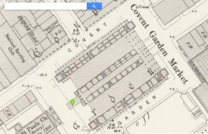
For this project I chose to look closely at Covent Garden which is a district in London that is mentioned in The Adventure of the Blue Carbuncle by Sir Arthur Conan Doyle. When Mr. Henry Baker approaches Holmes about the advertisement for the missing hat, he provides Holmes with valuable information for further investigation of the missing blue carbuncle that leads him to Covent Garden. Below is a screenshot of the area as seen on Victorian Google Maps:

coventgarden

After navigating all of the various digital archives to further research Covent Garden, I found the Charles Booth Online Archive and the British History archive to be particularly useful.   The other archives were either difficult to navigate or did not offer information that I found interesting enough to connect with the story. The Historical Eye archive failed to incorporate a type of search feature which would have been helpful in my research. This was one flaw of the archive in my opinion. The Old Bailey Online archive discussed criminal and law records which are interesting yet not something I wanted to discuss in this example. The Locating London archive only seemed to provide me with a map of where Covent Garden was located around this time period. It did not yield much qualitative information that I was seeking.


The British History Online archive is a great digital tool with a lot of rich data. It has a very sophisticated search engine that lets you precisely refine your results to find anything that you are looking for in the context of all British history. On this archive I was able to quickly search for Covent Garden and be presented with a lot of history about it. I discovered that the late 1800s was the greatest period of expansion in the entire history of the market. People could visit the market for fruits, produce, flowers, and other goods. The history provided by the archive was able to paint a nice image in my head of what Covent Garden looked like during the turn of the 20th century. Having that imagery allows me to gain a better understanding of the Holmes story and how society must have operated during this time period.


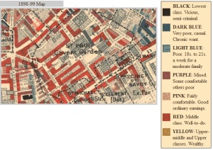
The map of Covent Garden on the Charles Booth Online Archive shows the range of poverty and wealth in the area circa 1898-99. As you can see on the screenshot below, this district of London was comprised mostly of middle class, well-to-do people. There are some poor and very poor areas interspersed throughout the district as well as a few places that are of the lowest class. This map and archive allows the researcher to develop an understanding of class and location in the late Victorian era which is valuable when comparing to the Sherlock Holmes story. It provides context for the setting which is a marketplace. It makes sense to the story that Covent Garden was mostly middle-class at the time of the publication of this story because it was a shopping area where the goose was sold.

charlesbooth