By Beth Wynne, Miranda Delancey, Devon Hauser, Jenna Corti, Danielle Koppie, Veronica Verstraten, and Rachel Janowsky.
digital mapping
Investigating Covent Garden
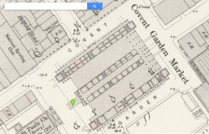
For this project I chose to look closely at Covent Garden which is a district in London that is mentioned in The Adventure of the Blue Carbuncle by Sir Arthur Conan Doyle. When Mr. Henry Baker approaches Holmes about the advertisement for the missing hat, he provides Holmes with valuable information for further investigation of the missing blue carbuncle that leads him to Covent Garden. Below is a screenshot of the area as seen on Victorian Google Maps:
After navigating all of the various digital archives to further research Covent Garden, I found the Charles Booth Online Archive and the British History archive to be particularly useful. The other archives were either difficult to navigate or did not offer information that I found interesting enough to connect with the story. The Historical Eye archive failed to incorporate a type of search feature which would have been helpful in my research. This was one flaw of the archive in my opinion. The Old Bailey Online archive discussed criminal and law records which are interesting yet not something I wanted to discuss in this example. The Locating London archive only seemed to provide me with a map of where Covent Garden was located around this time period. It did not yield much qualitative information that I was seeking.
The British History Online archive is a great digital tool with a lot of rich data. It has a very sophisticated search engine that lets you precisely refine your results to find anything that you are looking for in the context of all British history. On this archive I was able to quickly search for Covent Garden and be presented with a lot of history about it. I discovered that the late 1800s was the greatest period of expansion in the entire history of the market. People could visit the market for fruits, produce, flowers, and other goods. The history provided by the archive was able to paint a nice image in my head of what Covent Garden looked like during the turn of the 20th century. Having that imagery allows me to gain a better understanding of the Holmes story and how society must have operated during this time period.
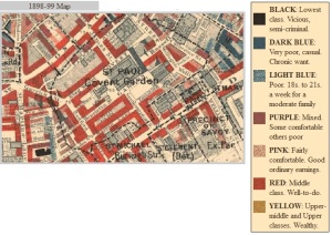
The map of Covent Garden on the Charles Booth Online Archive shows the range of poverty and wealth in the area circa 1898-99. As you can see on the screenshot below, this district of London was comprised mostly of middle class, well-to-do people. There are some poor and very poor areas interspersed throughout the district as well as a few places that are of the lowest class. This map and archive allows the researcher to develop an understanding of class and location in the late Victorian era which is valuable when comparing to the Sherlock Holmes story. It provides context for the setting which is a marketplace. It makes sense to the story that Covent Garden was mostly middle-class at the time of the publication of this story because it was a shopping area where the goose was sold.

