Discovering Tottenham Court Road

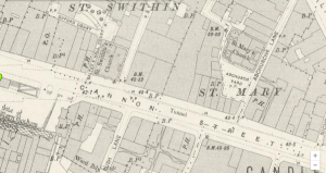
Tottenham Court Road is a road mentioned in the Sherlock Holmes story “The Adventure of the Blue Carbuncle.” It is here where Peterson, the commissionaire, witnessed a scuffle between a stranger and a group of “roughs,” presumably teenagers or young adults that loitered the area, on his way home that night from work As the strange man attempts to fight back he breaks the window of a shop on the road, suggesting that this is a commercial area. Since Peterson is a commissionaire, or a doorman, it can also be assumed that there are residences nearby.
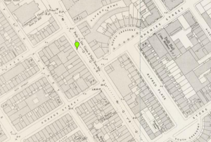
Tottenham Court Road; Victorian Google Maps
Closer view of Tottenham Court Road; Victorian Google Maps

I searched “Tottenham Court Road” in the Charles Booth Online Archive (http://goo.gl/JgRmhL) where it provided this map:

boothpovtcr

The most prominent colors on the map seem to be red and pink. Red on the map symbolizes individuals who were “middle class” and “well-to-do” while the pink symbolizes those who were “fairly comfortable” and made “good ordinary earnings.” It can be assumed that most of the people who lived in this area owned or worked in a shop in the area, which would provide them with good or excellent wages. However, despite the presence of the middle class, there are small areas where there is greater poverty. Moving a little farther away from Tottenham Court Road, shades of light and dark blue begin to appear on the map, symbolizing the poor, who earned “18s to 21s a week for a moderate family” and the very poor, described as “casual” with “chronic want.”

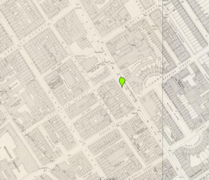
The zoomed out map appears here:

povtcr

Even though Tottenham Court Road seems to be a busy commercial destination, it is not a surprise that the strange man with the goose was involved in a row in this area, especially considering it was at a time where most shops might be closed for the evening, meaning there were less people around. The individuals who lived in the poorer areas surrounding Tottenham Court Road most likely loitered these areas at night. Because of the goose the man was carrying, he seems to be a prime victim for poor assailants. Because of this connection to the story and the real-life area, I was interested about what other crimes were committed in this area.

I searched Old Bailey Online (http://www.oldbaileyonline.org) see what crimes were committed on Tottenham Court Road and the areas surrounding it. Many of the crimes committed in this area are relevant to the types of crimes Sherlock Holmes dealt with. The most common crime seemed to be theft with counts of simple things such as pocketpicking to more serious counts of cases like grand larceny and violent theft. There were also counts of murder and sexual assaults in the area, though these were very rare. As unfortunate as it is, It is safe to assume that the theft taking place in the area is due to the road being in close proximity to more impoverished areas. Again, it connects the violent row between the stranger with the goose and the group of assailants.

Overall, this project was very helpful in learning about different areas in Sherlock Holmes’ London, how they were in real life, and what purpose they served in the stories. Some of the sights were easier to manage than others, but all of them had an abundance of information that helped pinpoint specific details about the specific areas and/or landmarks.
GIS Blog for Piccadilly Circus


Screen Shot 2014-11-09 at 7.50.00 PM

In the Sherlock Holmes stories this is where John Watson hears about Sherlock for the first time as he is looking for a flatmate to move in with. Gaining insight from the Historical Eye webpage I learned a lot about this area in the past and how it is like today. One of the main attractions of Piccadilly Circus is the Burlington house, which still remains today the home of the Royal Academy as it did during Victorian times. A site for entertainment in 1812 was the Egyptian Hall which is no longer there today. The area in general was a place for shopping and entertainment. The London Pavillion was a variety theatre which was very popular during the 1800’s. In the middle of Piccadilly Circus still remains the bronze Shaftesbury Memorial fountain made by Alfred Gilbert.  The Historical Eye gave a very brief overview of the area, but it was helpful for finding more information because I knew what to look for.

I then used the British History online database and found more information about the area along with more pictures. From the pictures, this area seemed very busy and loud. It reminds me of an older version of Times Square in New York, with all the illuminated advertising and signs everywhere. According to the British History online database there was a lot of controversy about these illuminated advertisements because the lights could cause danger to drivers. Laws were created due to the new additions of lights to advertisements. Due the the lavishness of the lights and the types of buildings, it can be concluded that the area was fairly well to do and could afford to have electricity and the means to keep all the storefronts and entertainment businesses up and running.


“Piccadilly to Oxford Street.” Historicaleye.com. N.p., n.d. Web. 09 Nov. 2014.


‘The rebuilding of Piccadilly Circus and the Regent Street Quadrant’, Survey of London: volumes 31 and 32: St James Westminster, Part 2 (1963), pp. 85-100. URL: http://www.british-history.ac.uk/report.aspx?compid=41456&strquery=piccadilly circus Date accessed: 10 November 2014.

GIS: The Final Problem–Vere Street

For my GIS (Geographic Information Systems) project on Sherlock Holmes, I picked Vere Street, where in “The Final Problem,” where Sherlock almost gets hit in the head by a “falling” brick. This is the second attempt on his life in this story. The following quote is the context of the mention of the location within the story: “I kept to the pavement after that, Watson, but as I walked down Vere Street a brick came down from the roof of one of the houses and was shattered to fragments at my feet. I called the police and had the place examined. There were slates and bricks piled up on the roof preparatory to some repairs, and they would have me believe that the wind had toppled over one of these. Of course I knew better, but I could prove nothing.” (The Final Problem)

Screenshot1

I looked on many of the sites listed to provide what the mention of tis street could have to do with the story as a whole. The first data I came across was from the Booth Poverty Map:

Screenshot2

This map shows that in, and around Vere Street there is a wide mixture of people. It almost covers the whole spectrum in this tiny area, going from blue (the poorest) to yellow (the wealthiest). Could this have something to do with the construction going on? Possibly. You would think that the police, though, would have been a little more attentive in such a rich area. Next I looked on Old Bailey Online, but Vere Street yielded no results, so I tried the keyword “brick,” and there was only one result of someone being killed by a brick
Screenshot3

hmmm… not exactly a brick falling from a ledge… But I kept trying on the other databases. Locating London gave me some…weird results. It gave me about 5 pins near Vere Street, but when i clicked on them all it said was “No Results.” alright…..So my last hope for some kind of data was British Histories. I searched Vere Street again…but alas, only one result, which seemed to be a log of a tax collector, or a tax assessment.

Capture

So not much about the cconstruction history, but possibly something can be said here about the wealth of the people here. It seems thaat most of the people renting here are pretty upper to middle class, so it still surprises me that, in this story the police didn’t investigate any further…perhaps somebody paid them not to? That might be what Doyle was trying to get across by using this particular street: that whoever is trying to kill Holmes, has a lot of power.

~ Austin Carpentieri

Holmes in London Maps

I chose to analyze Cannon Street during the Victorian London era. Cannon Street can be found in the Sherlock Holmes story The Man with the Twisted Lip. In the story, a man by the name of Neville St. Clair who had no occupation but a lot of money was interested in purchasing businesses on Cannon Street.

Cannon Street

After using the search tools provided to us, I learned that Cannon Street had a number of murders and other crimes that occurred there in much earlier years. One such event took place on September 6th, 1693. Adam Martyn and Richard Norman Carmen were both tried and found guilty of manslaughter when they drove their carts into a young child resulting in her death (http://www.oldbaileyonline.org/browse.jsp?id=t16930906-6&div=t16930906-6&terms=Cannon|Street#highlight). Another event occurred on Cannon Street on December 10th, 1684 in which a woman named Anne Gardener was tried and found guilty of deception and fraud when she stole rows of silk adding up to 81 GBP (http://www.oldbaileyonline.org/browse.jsp?id=t16841210-35&div=t16841210-35&terms=Cannon|Street#highlight). I also found out that through using “British Histories”, Cannon Street was originally called Candlewick Street based on the fact that many candle-makers worked and lived there.

Another mysterious murder occurred on Cannon Street. In April of 1886, Sarah Millson answered the bell at the business where she worked around 9pm. At around 10pm,  a woman who worked with her by the name of Elizabeth Lowes went down to the front door where Sarah Millson was an hour before, only to find her dead and profusely bleeding from wounds on the top of her head. Evidence from the coroner suspects that the wounds were delivered with a crowbar that could have also been used to break into the premises. (http://www.british-history.ac.uk/report.aspx?compid=45065&strquery=Cannon%20Street)

Mapping Fleet Street in the Victorian Age

I chose to search the popular London location Fleet Street which is mentioned in the Sherlock Holmes story “The Red-Headed League.” This tale is one of the less dramatic mysteries that Holmes explores, and when I first read it, the mention of Fleet Street caught my eye. I primarily knew the street as home to Stephen Sondheim’s Demon Barber and Mrs. Lovett’s meat pies. In the story of The Red-Headed League, a man gets tricked into working at an office on Fleet Street, assisting with the manual copying of the Encyclopedia Britannica. His new “league” mysteriously disbands very suddenly and with a turn of events, we learn that the office on Fleet Street was a decoy for another crime to take place. As the map from Victorian Google Maps below shows, Fleet Street is broad and stretches across several intersections in central London.

Fleet Street on the Victorian Google Maps
Fleet Street in the Victorian Age, Courtesy of Victorian Google Maps

Fleet Street was known as “a tavern street, as well as a literary centre,” according to historicaleye.com, a website composed of a compilation of academic works about various historical events/locations. Through exploring this and several other sites, I learned that Fleet Street is known as more than Sweeney Todd’s home. In fact, by 1896 several notable writers are cited as having inhabited the street’s pubs; “Shakespeare, Ben Johnson, Raleigh, Dryden, Johnson, Goldsmith…are closely associated with this famous street” (historialeye.com). In regards to this website as a scholarly archive tool, the section on Fleet Street and The Strand on historicaleye.com is difficult to find if accidentally navigated away from. There seem to be two very different parts  of this website – the Then and Now section about London that features historical summaries of London locations in 1896, and the newly “renovated” part of the site that is exposed when clicking on the home button. With no search bar on either of these parts of historicaleye.com, exploration was left only to clicking around the tabs most relevant to London.

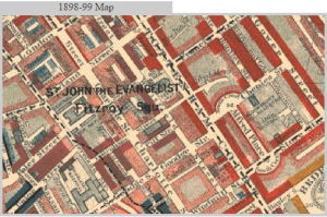
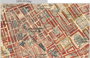
The interesting combination of literary greats and taverns is reflected in the socioeconomic status of Fleet Street. Using the Charles Booth Online Archive (http://goo.gl/Jg­RmhL), I looked for the street to learn about its economic makeup in the 1890s. Based on the Charles Booth Poverty Classification Legend, the map below shows that the end of Fleet Street where it converges with the Strand had many middle-class/well-to-do individuals living here, as noted by the red markings. Both Victorian Google Maps and the Charles Booth map note that there are many banks on the part of Fleet Street that approaches The Strand, so the increase in well-to-do individuals correlates well.  Though the map is not very clear to read, I interpret the light blue/gray along the center of Fleet Street to represent the “poor 18-21 year olds” from the Booth Poverty Classification Legend. To the right of Fleet Street as it approaches St. Bride Street, all of light pink represents the population of people who were “fairly comfortable” with “good ordinary earnings.” From well-to-do individuals to poor young adults, this street had a variety of people passing through it in the late 1800’s, further  verifying the reputation of taverns and great Victorian writers in one place.

Using Charles Booth's Poverty Classification Legend, this map shows that the end of Fleet Street that converges to The Strand had many middle-class/well-to-do individuals living here as noted by the red markings.
Fleet Street on a 1898-1899 Map of London


The broad range of socioeconomic status on Fleet Street prompted interest for me to explore the types of crime that were documented at the time of the Charles Booth Poverty map. Below are cases that either took place on or involved Fleet Street and therefore surfaced as search results on Old Bailey Online (www.oldbaileyonline.org/static/London-life19th.jsp), an archive that houses centuries of London court cases. Limiting my search to 1896-1898 to coincide with the Poverty Classification map, I found an interesting trend in crimes in the late 1890s on Fleet Street. If I were topic modeling the cases below, it’d be easy to detect the highest trending topic for court cases…theft. Two counts of burglary, two counts of pocketpicking, and two counts of fraud all point to the majority of crimes revolving around stealing money on this street. The somewhat broad range of socioeconomic status may have been responsible for these crimes. These court case crimes, including the extreme manslaughter charge and then perjury and larceny charges all sound like the London that Arthur Conan Doyle depicts by means of Sherlock’s cases, while also relating to the variation of inhabitants’ economic statuses at the time.

A list of cases from the Old Bailey Online Archive that were documented as taking place on Fleet Street in the Victorian Age


Sources:

“Booth Poverty Map & Modern Map (Charles Booth Online Archive).” London School of Economics & Political Science, Web. 09 Nov. 2014.


Rees, Simon. “Fleet Street and the Strand.” Historicaleye.com. Simon Rees. Web. 09 Nov. 2014.


Tim Hitchcock, Robert Shoemaker, Clive Emsley, Sharon Howard and Jamie McLaughlin, et al., The Old Bailey Proceedings Online, 1674-1913 (www.oldbaileyonline.org, version 7.0, 24 March 2012). 09 Nov. 2014.


The Lyceum Theatre

A meeting place between Holmes and the mysterious villains of The Sign of the Four, the Lyceum is a well known and prestigious theatre in Westminster, right off the Strand. The current Lyceum was opened in 1834 after its previous name bearer was destroyed in a fire in 1830- the previous theatre was located just across the street (Lloyd “The Lyceum Theatre, Wellington Street, London – Also known as The Theatre Royal, English Opera House / Royal Lyceum Theatre / English Opera House / Palais de Dance / Mecca Ballroom”). Since its reopening, the theatre has played host to a variety of productions. This pedigree was established during its ownership by one Henry Irving, who produced several adaptations of Shakespeare works during his tenure (starting 1878). It continued to operate through the 20th century, even surviving the Blitz, to play host to bands such as The Clash, Queen, and U2. It closed in 1986 for renovations, then reopened in 1996 to host Jesus Christ, Superstar, and, since 1999, has been the home of London’s production of The Lion King(“Lyceum Theatre London”).

The Wellington Street locale has been a centerpiece of London’s performance arts for almost two centuries, but a cursory inspection of the Old Bailey Archives would show a variety of theft and related crimes surrounding the theatre. A simple example would be the case of the theft of the pocketwatch of one Chahata Jassa, where a pickpocket by the name of James George was able to easily steal the item amid the clutter of the crowd. The theatre, being a prominent landmark, made for an easy meeting place for cases of assault and extortion, like that of John Joyce in August 1844. Simply, like any popular scene, this storied house of drama was party to plenty of it- not all on stage.

lyceum

Citations

Lloyd, Arthur. “The Lyceum Theatre, Wellington Street, London – Also Known as The Theatre Royal, English Opera House / Royal Lyceum Theatre / English Opera House / Palais De Dance / Mecca Ballroom.” The Lyceum Theatre, Wellington Street, London – Also Known as The Theatre Royal, English Opera House / Royal Lyceum Theatre / English Opera House / Palais De Dance / Mecca Ballroom. Web. 9 Nov. 2014.

“Lyceum Theatre London | Lion King Tickets.” Lyceum Theatre London. Web. 9 Nov. 2014. <http://www.lyceumtheatrelondon.org/>.

Discovering Leadenhall Street from “A Case of Identity”

I decided to investigate Leadenhall Street, the street that Mr. Hosmer Angel’s office is located on in “A Case of Identity.” In the story, Miss Sutherland knows that Mr. Hosmer Angel works in an office on Leadenhall Street, but does not know much more about him than that. Below is the screenshot of Leadenhall Street from the Victorian Google Maps:

Leadenhall Street
Leadenhall Street

After searching for Leadenhall Street on Old Bailey Online, I found that Leadenhall Street must have been quite a busy street and home to multiple shops, businesses, and homes. It must have been some kind of a main street in the city because it was so busy and home to so many businesses. Out of all of the sites listed for the assignment, Old Bailey Online was the only resource that gave me specific information about happenings on Leadenhall Street. There were multiple instances in which crimes were committed and bodies were found on Leadenhall Street, such as the murder of Dr. Andrew Clenche (Old Bailey Online, Henry Harrison Killing – http://www.oldbaileyonline.org/browse.jsp?id=t16920406-1&div=t16920406-1&terms=leadenhall|street#highlight).

Searching for Leadenhall Street using British History Online brought me to the page “Leadenhall Street and the Old East India House.” Leadenhall Street was the home of the East India House after the great fire, as Sir William Craven leased the property of his house on Leadenhall Street to the East India Company. The company existed in order to trade with the East Indies. (Old Bailey Online, “Leadenhall Street and the Old East India House – http://www.british-history.ac.uk/report.aspx?compid=45089&strquery=leadenhall).

Tottenham Court Road and Goodge Street- Conan Doyle’s The Adventure of the Blue Carbuncle

Untitled

Tottenham Court Road and Goodge Street are mentioned at the very beginning of in The Adventure of the Blue Carbuncle. The commissionaire, Peterson, witnessed an attempt mugging and fight between a man and a “knot of roughs” around the corner of Tottenham Court Road and Goodge Street. This is a commercial area (the man smashed a shop window).

In the Charlie Booth Online Archive, I searched for “Goodge Street” to see the social standing and wealth (or lack there of) of the surrounding areas. Tottenham Court Road is almost all red (“Middle class. Well to do.”) and Goodge Street is mainly surrounded by pink (“Fairly comfortable. Good ordinary earnings.”). In this area there are pockets of light blue (“Poor. 18s. to 21s. a week for a moderate family”) and purple (“Mixed. Some comfortable others poor”). I also noticed that not far, just off of Goodge Street and Charlotte Street, there is a large area that is dark blue (“Very poor, casual. Chronic want.”).

In relation to the story; Tottenham Court Road itself is pretty well to do, however, this moment in the story when the man was attacked was at night. A commercial area at night can be pretty seedy, not to mention it is fairly close to an extremely poor neighborhood.

goodge street

The British History Online Archive has a plethora of information on the streets and roads of London.

http://www.british-history.ac.uk/report.aspx?compid=65160&strquery=goodge%20street

Through this page, I found out that Goodge Street was also a commercial street. Many of these buildings had different structures (different number of windows, different styles, etc.) They were kept around the same height. Many of the buildings were raided and destroyed, so perhaps this explains some of the differences in the buildings.

I was also able to find some information in the Old Bailey Archive. I found that the crimes reported in this area were mainly theft, pickpocketing, shoplifting, larceny, and embezzlement. I also noticed, however, that Goodge Street was mentioned in relation to were someone lived or worked. There were people who worked in a shop close by (“gin shop”, “coal shed”) or lived by the street. The corner of Goodge Street and Tottenham Court Road were also discussed as a place to meet up with people. This makes sense since it is such a commercial area.

Investigating Covent Garden

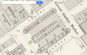
For this project I chose to look closely at Covent Garden which is a district in London that is mentioned in The Adventure of the Blue Carbuncle by Sir Arthur Conan Doyle. When Mr. Henry Baker approaches Holmes about the advertisement for the missing hat, he provides Holmes with valuable information for further investigation of the missing blue carbuncle that leads him to Covent Garden. Below is a screenshot of the area as seen on Victorian Google Maps:

coventgarden

After navigating all of the various digital archives to further research Covent Garden, I found the Charles Booth Online Archive and the British History archive to be particularly useful.   The other archives were either difficult to navigate or did not offer information that I found interesting enough to connect with the story. The Historical Eye archive failed to incorporate a type of search feature which would have been helpful in my research. This was one flaw of the archive in my opinion. The Old Bailey Online archive discussed criminal and law records which are interesting yet not something I wanted to discuss in this example. The Locating London archive only seemed to provide me with a map of where Covent Garden was located around this time period. It did not yield much qualitative information that I was seeking.


The British History Online archive is a great digital tool with a lot of rich data. It has a very sophisticated search engine that lets you precisely refine your results to find anything that you are looking for in the context of all British history. On this archive I was able to quickly search for Covent Garden and be presented with a lot of history about it. I discovered that the late 1800s was the greatest period of expansion in the entire history of the market. People could visit the market for fruits, produce, flowers, and other goods. The history provided by the archive was able to paint a nice image in my head of what Covent Garden looked like during the turn of the 20th century. Having that imagery allows me to gain a better understanding of the Holmes story and how society must have operated during this time period.


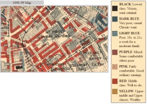
The map of Covent Garden on the Charles Booth Online Archive shows the range of poverty and wealth in the area circa 1898-99. As you can see on the screenshot below, this district of London was comprised mostly of middle class, well-to-do people. There are some poor and very poor areas interspersed throughout the district as well as a few places that are of the lowest class. This map and archive allows the researcher to develop an understanding of class and location in the late Victorian era which is valuable when comparing to the Sherlock Holmes story. It provides context for the setting which is a marketplace. It makes sense to the story that Covent Garden was mostly middle-class at the time of the publication of this story because it was a shopping area where the goose was sold.

charlesbooth


GIS Unit: Discovering Leatherhead

For this assignment, I decided to research Leatherhead, Surrey– where the Step father’s estate is and where most of The Adventure of the Speckled Band takes place.

Here is an overview of what the place looks like.

Screen Shot 2014-11-06 at 2.00.27 PM


From this picture, it is safe to assume this is a quaint rural place in England.

To look for research, I started  at British History Online, which states it contains “primary and secondary sources” from British history.  I later looked on the other two sites but could not find anything really relevant to the description or importance of Leatherhead.  In one source from Victoria Country History published in 1911, they state “Leatherhead is a small town or large village” (British History Online). This source also states Leatherhead is dominated by agricultural and has always been known as  an “old county town” (British History Online). This same source talks of the various lords who have owned manors in Leatherhead as early as the 1200s (British History Online). Interestingly, the Victoria Country History  also claims “Leatherhead was quite possibly the meeting-place of the Hundred Court of Copthorne. (fn. 5) It is also geographically near the centre of the county, and a convenient place for the meetings of influential people in Surrey.”

All this information is extremely relevant to The Adventure of the Speckled Band. First of all, the author wants to create a calm and settling environment so the Step Father seems very out of place and dangerous there. What better place than the quaint country town of Leatherhead? In addition, The step father lives on a manor, so it makes sense for his manor to be in a place with a known history of having manors. Finally, if Leatherhead is near the center of the country, it would be accessible and realistic for Holmes to travel there from London– it is not a far fetch idea for him to get to Leatherhead to investigate a case.

Basically, Leatherhead, Surrey fits the plot of this Holmes story perfectly. It makes for the perfect environment for the story to take place in and makes the details to the story realistic.

Screen Shot 2014-11-09 at 3.50.34 PM

Screen Shot 2014-11-09 at 3.51.15 PM

Screen Shot 2014-11-09 at 3.51.55 PM

Screen Shot 2014-11-09 at 3.53.22 PM